Vale of White Horse
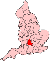
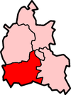
Vale of White Horse is een Engels district in het shire-graafschap (non-metropolitan county OF county) Oxfordshire en telt 134.000 inwoners. De oppervlakte bedraagt 578 km². Hoofdplaats is Abingdon.
| Niet-metropolitaans district in Engeland | |||
  | |||
| Situering | |||
| Land | Engeland | ||
| County | Oxfordshire | ||
| Regio | South East England | ||
| Coördinaten | 51°36'NB, 1°30'WL | ||
| Algemeen | |||
| Oppervlakte | 577,6287[1] km² | ||
| Inwoners (2018[2]) | 133732 (232 inw./km²) | ||
| Hoofdplaats ONS-code | Abingdon E07000180 | ||
| |||
Van de bevolking is 15,4% ouder dan 65 jaar. De werkloosheid bedraagt 1,6% van de beroepsbevolking (cijfers volkstelling 2001).
Het district is vernoemd naar het Witte paard van Uffington.
Civil parishes in district Vale of White Horse
Abingdon on Thames, Appleford-on-Thames, Appleton-with-Eaton, Ardington, Ashbury, Baulking, Besselsleigh, Blewbury, Bourton, Buckland, Buscot, Charney Bassett, Childrey, Chilton, Coleshill, Compton Beauchamp, Cumnor, Denchworth, Drayton, East Challow, East Hanney, East Hendred, Eaton Hastings, Fernham, Frilford, Fyfield and Tubney, Garford, Goosey, Great Coxwell, Great Faringdon, Grove, Harwell, Hatford, Hinton Waldrist, Kennington, Kingston Bagpuize with Southmoor, Kingston Lisle, Letcombe Bassett, Letcombe Regis, Little Coxwell, Littleworth, Lockinge, Longcot, Longworth, Lyford, Marcham, Milton, North Hinksey, Pusey, Radley, Shellingford, Shrivenham, South Hinksey, Sparsholt, St. Helen Without, Stanford in the Vale, Steventon, Sunningwell, Sutton Courtenay, Uffington, Upton, Wantage, Watchfield, West Challow, West Hanney, West Hendred, Woolstone, Wootton, Wytham.
Bronnen, noten en/of referenties
|