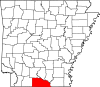
Union County (Arkansas)
Union County is een county in de Amerikaanse staat Arkansas.
| County in de Verenigde Staten | |||
 | |||
| Situering | |||
| Staat | Arkansas | ||
| Coördinaten | 33°11'14"NB, 92°35'29"WL | ||
| Algemeen | |||
| Oppervlakte | 2.733 km² | ||
| - land | 2.691 km² | ||
| - water | 42 km² | ||
| Inwoners (2000) | 45.629 (17 inw./km²) | ||
| Overig | |||
| Zetel | El Dorado | ||
| FIPS-code | 05139 | ||
| Opgericht | 1829 | ||
| Foto's | |||
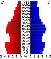 Bevolkingspiramide Union County | |||
| Statistieken volkstelling Union County | |||
| |||
De county heeft een landoppervlakte van 2.691 km² en telt 45.629 inwoners (volkstelling 2000). De hoofdplaats is El Dorado.
Bevolkingsontwikkeling
| Historische inwonertallen | |||
|---|---|---|---|
| Jaar | Inwoners | % ± | |
| 1900 | 22.495 | ||
| 1910 | 30.723 | 36,6% | |
| 1920 | 29.691 | −3,4% | |
| 1930 | 55.800 | 87,9% | |
| 1940 | 50.461 | −9,6% | |
| 1950 | 49.686 | −1,5% | |
| 1960 | 49.518 | −0,3% | |
| 1970 | 45.428 | −8,3% | |
| 1980 | 48.573 | 6,9% | |
| 1990 | 46.719 | −3,8% | |
| 2000 | 45.629 | −2,3% | |
| Bron: (en) Historical Decennial Census Population | |||
This article is issued from
Wikipedia.
The text is licensed under Creative
Commons - Attribution - Sharealike.
Additional terms may apply for the media files.