Tyfoonseizoen van de Grote Oceaan 2014
Het tyfoonseizoen van de Grote Oceaan 2014 duurt het hele jaar door en beslaat het gebied van de westelijke Grote Oceaan, westelijk van de datumgrens en noordelijk van de evenaar. Weliswaar loopt het seizoen het hele jaar door, toch vormen de meeste tropische cyclonen zich in de maanden mei tot november.
Tyfoonseizoen van de Grote Oceaan 2014
| ||||
 | ||||
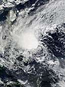
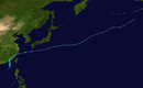
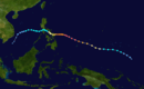
Overzichtskaart van het seizoen | ||||
| Formatie eerste storm | 10 januari 2014 | |||
| Oplossen laatste storm | 1 januari 2015 | |||
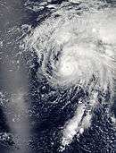
| Sterkste storm | Vongfong met 900 hPa, 215 km/h (1-min continu) | |||
| Totaal depressies | 30 | |||
| Totaal stormen | 12 | |||
| Tyfonen | 11 | |||
| Supertyfonen | 8 (onofficieel) | |||
| Slachtoffers | 538 | |||
| Schade | US$ 8,41 miljard (prijspeil 2014) | |||
| ||||
Cyclonen
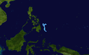
Tropische storm Lingling (Agaton), 01W
Tropische storm Lingling (Agaton), 01W
| |||||
| Tropische storm (JMA) Tropische storm (SSHS) | |||||
| |||||
| Duur | 15 januari - 20 januari | ||||
| Maximum windsnelheid | 10-minuten doorstaand: 65 km/h 1-minuut doorstaand: 65 km/h | ||||
| Laagste luchtdruk | 1002 hPa | ||||
| |||||
Tropische storm Kajiki (Basyang), 02W
Tropische storm Kajiki (Basyang), 02W
| |||||
| Tropische storm (JMA) Tropische storm (SSHS) | |||||
| |||||
| Duur | 29 januari - 1 februari | ||||
| Maximum windsnelheid | 10-minuten doorstaand: 65 km/h | ||||
| Laagste luchtdruk | 1000 hPa | ||||
| |||||

Tyfoon Faxai, 03W
Tyfoon Faxai, 03W
| |||||
| Tyfoon (JMA) Categorie 1 tyfoon (SSHS) | |||||
| |||||
| Duur | 26 februari - 6 maart | ||||
| Maximum windsnelheid | 10-minuten doorstaand: 120 km/h | ||||
| Laagste luchtdruk | 975 hPa | ||||
| |||||

Tropische depressie (Caloy), 04W
Tropische storm Peipah (Domeng), 05W
Zware tropische storm Tapah, 06W
Zware tropische storm Tapah, 06W
| |||||
| Zware tropische storm (JMA) Categorie 1 tyfoon (SSHS) | |||||
| |||||
| Duur | 27 april - 2 mei | ||||
| Maximum windsnelheid | 10-minuten doorstaand: 95 km/h | ||||
| Laagste luchtdruk | 985 hPa | ||||
| |||||

Tropische storm Hagibis, TS 1407, 07W
Tropische storm Hagibis, TS 1407, 07W
| |||||
| Tropische storm (JMA) Tropische storm (SSHS) | |||||
| |||||
| Duur | 13 juni - 18 juni | ||||
| Maximum windsnelheid | 10-minuten doorstaand: 75 km/h | ||||
| Laagste luchtdruk | 994 hPa | ||||
| |||||

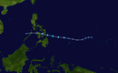
Laat op 8 juni begon, net als bij de formatie van Mitag, een kleine circulatie zicht te ontwikkelen in de Zuid-Chinese Zee. Vroeg op 11 juni werd het systeem opgewaardeerd tot een depressie en op 13 juni classificeerde het JMA het als een tropische depressie. Intussen begon het systeem langzaam in noordoostelijke richting te bewegen. Vroeg op 14 juni werd door het JTWC een TCFA waarschuwing afgegeven voor de depressie en later op dag waardeerde ook het JTWC het systeem op tot de tropische depressie 07W en gelijkertijd waardeerde het JMA het systeem op tot de tropische storm Hagibis. Vroeg op 15 juni kwam Hagibis in het zuiden van China.[1] Op 16 juni werden door het JMA en het JTWC alle waarschuwingen stopgezet nadat het systeem snel afzwakte tot een depressie boven land. De restanten van het systeem trokken verder noordwaarts. Op 17 juni bogen de restanten af naar het oosten en kwamen weer boven zee, waar het systeem opnieuw door het JMA als tropische storm werd geclassificeerd. Hagibis werd vroeg op 18 juni extratropisch.
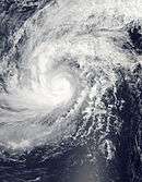
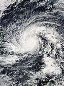
Tyfoon Hagupit (Ruby), TY 1422, 22W
Tyfoon Hagupit (Ruby), TY 1422, 22W
| |||||
| Tyfoon (JMA) Categorie 3 tyfoon (SSHS) | |||||
| |||||
| Duur | 1 december - actief | ||||
| Maximum windsnelheid | 10-minuten doorstaand: 175 km/h 1-minuut doorstaand: 185 km/h | ||||
| Laagste luchtdruk | 935 hPa | ||||
| |||||
Bronnen, noten en/of referenties
|
| Tyfoonseizoenen van de Grote Oceaan |
|---|
|
20e eeuw: 1900 · 1901 · 1902 · 1903 · 1904 · 1905 · 1906 · 1907 · 1908 · 1909 · 1910 · 1911 · 1912 · 1913 · 1914 · 1915 · 1916 · 1917 · 1918 · 1919 · 1920 · 1921 · 1922 · 1923 · 1924 · 1925 · 1926 · 1927 · 1928 · 1929 · 1930 · 1931 · 1932 · 1933 · 1934 · 1935 · 1936 · 1937 · 1938 · 1939 · 1940 · 1941 · 1942 · 1943 · 1944 · 1945 · 1946 · 1947 · 1948 · 1949 · 1950 · 1951 · 1952 · 1953 · 1954 · 1955 · 1956 · 1957 · 1958 · 1959 · 1960 · 1961 · 1962 · 1963 · 1964 · 1965 · 1966 · 1967 · 1968 · 1969 · 1970 · 1971 · 1972 · 1973 · 1974 · 1975 · 1976 · 1977 · 1978 · 1979 · 1980 · 1981 · 1982 · 1983 · 1984 · 1985 · 1986 · 1987 · 1988 · 1989 · 1990 · 1991 · 1992 · 1993 · 1994 · 1995 · 1996 · 1997 · 1998 · 1999 |