Tewkesbury (district)
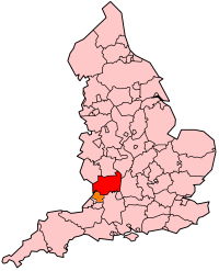
Tewkesbury is een Engels district in het shire-graafschap (non-metropolitan county OF county) Gloucestershire aan de Avon nabij de samenvloeiing met de Severn en telt 93.000 inwoners. De oppervlakte bedraagt 414 km².
| Niet-metropolitaans district in Engeland | |||
  | |||
| Situering | |||
| Land | Engeland | ||
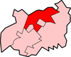
| County | Gloucestershire | ||
| Regio | South West England | ||
| Coördinaten | 52°0'0"NB, 2°10'0"WL | ||
| Algemeen | |||
| Oppervlakte | 414,4144[1] km² | ||
| Inwoners (2018[2]) | 92599 (223 inw./km²) | ||
| ONS-code | E07000083 | ||
| |||
Van de bevolking is 17,8% ouder dan 65 jaar. De werkloosheid bedraagt 2,0% van de beroepsbevolking (cijfers volkstelling 2001).
In 1471 vond hier een der bloedigste slagen uit de Rozenoorlog plaats.
Plaatsen in district Tewkesbury
Civil parishes in district Tewkesbury
Alderton, Ashchurch Rural, Ashleworth, Badgeworth, Bishop’s Cleeve, Boddington, Brockworth, Buckland, Chaceley, Churchdown, Deerhurst, Down Hatherley, Dumbleton, Elmstone Hardwicke, Forthampton, Gotherington, Great Witcombe, Gretton, Hasfield, Hawling, Highnam, Hucclecote, Innsworth, Leigh, Longford, Maisemore, Minsterworth, Northway, Norton, Oxenton, Prescott, Sandhurst, Shurdington, Snowshill, Southam, Stanton, Stanway, Staverton, Stoke Orchard, Sudeley, Teddington, Tewkesbury, Tirley, Toddington, Twigworth, Twyning, Uckington, Wheatpieces, Winchcombe, Woodmancote.
Bronnen, noten en/of referenties
|