Shire of Northampton
Shire of Northampton is een Local Government Area (LGA) in Australië in de staat West-Australië. Shire of Northampton telde 3.319 inwoners in 2016. De hoofdplaats is Northampton.
| Local Government Area van Australië | |||
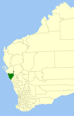 Locatie van Shire of Northampton in West-Australië | |||
| Situering | |||
| Staat | West-Australië | ||
| Hoofdplaats | Northampton | ||
| Coördinaten | 28°21'4"ZB, 114°37'41"OL | ||
| Algemene informatie | |||
| Oppervlakte | 13.737,8 km² | ||
| Inwoners | 3.319 (2016)[1] | ||
| Overig | |||
| Wards | 6 | ||
| Website | (en) Shire of Northampton | ||
| |||
Geschiedenis
Op 25 januari 1871 werd het Mines Road District gesticht. Op 10 februari 1887 werd het hernoemd naar het Northampton Road District en op 23 juni 1961 naar de Shire of Northampton.[2]
Plaatsen, dorpen en lokaliteiten
- Northampton
- Ajana
- Alma
- Barrel Well Community
- Binnu
- Bowes
- East Bowes
- Horrocks
- Houtman Abrolhos
- Isseka
- Kalbarri
- nationaal park Kalbarri
- Lynton
- Ogilvie
- Port Gregory
- Sandy Gully
- Yallabatharra
Bronnen, noten en/of referenties
|
Geplaatst op: 03-09-2008 |
Dit artikel is een beginnetje over landen & volken. U wordt uitgenodigd om op bewerken te klikken om uw kennis aan dit artikel toe te voegen. |
This article is issued from
Wikipedia.
The text is licensed under Creative
Commons - Attribution - Sharealike.
Additional terms may apply for the media files.