Shire of Kojonup
Shire of Kojonup is een Local Government Area (LGA) in Australië in de staat West-Australië. Shire of Kojonup telde 1.985 inwoners in 2016. De hoofdplaats is Kojonup.
| Local Government Area van Australië | |||
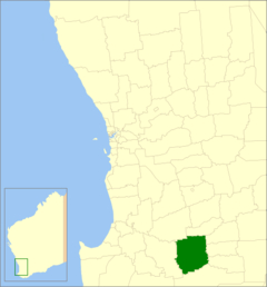 Locatie van Shire of Kojonup in West-Australië | |||
| Situering | |||
| Staat | West-Australië | ||
| Hoofdplaats | Kojonup | ||
| Coördinaten | 33°50'17"ZB, 117°9'7"OL | ||
| Algemene informatie | |||
| Oppervlakte | 2.932,2 km² | ||
| Inwoners | 1.985 (2016)[1] | ||
| Overig | |||
| Wards | geen | ||
| Website | (en) Shire of Kojonup | ||
| |||
Geschiedenis
Op 5 december 1871 werd het Kojonup Road District gesticht. Het Kojonup Road District werd vervangen door de Shire of Kojonup op 23 juni 1961.[2]
Geografie
De volgende plaatsen liggen in het lokale bestuursgebied:[3]
- Kojonup
- Boscabel
- Cherry Tree Pool
- Jingalup
- Lumeah
- Muradup
- Mobrup
- Qualeup
- Wahkinup
Bronnen, noten en/of referenties
|
Geplaatst op: 03-09-2008 |
Dit artikel is een beginnetje over landen & volken. U wordt uitgenodigd om op bewerken te klikken om uw kennis aan dit artikel toe te voegen. |
This article is issued from
Wikipedia.
The text is licensed under Creative
Commons - Attribution - Sharealike.
Additional terms may apply for the media files.