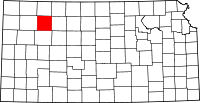
Sheridan County (Kansas)
Sheridan County is een county in de Amerikaanse staat Kansas.
| County in de Verenigde Staten | |||
 | |||
| Situering | |||
| Staat | Kansas | ||
| Coördinaten | 39°21'0"NB, 100°25'48"WL | ||
| Algemeen | |||
| Oppervlakte | 2.323 km² | ||
| - land | 2.322 km² | ||
| - water | 1 km² | ||
| Inwoners (2000) | 2.813 (1 inw./km²) | ||
| Overig | |||
| Zetel | Hoxie | ||
| FIPS-code | 20179 | ||
| Opgericht | 1880 | ||
| Foto's | |||
 Bevolkingspiramide Sheridan County | |||
| Statistieken volkstelling Sheridan County | |||
| |||
De county heeft een landoppervlakte van 2.322 km² en telt 2.813 inwoners (volkstelling 2000). De hoofdplaats is Hoxie.
Bevolkingsontwikkeling
| Historische inwonertallen | |||
|---|---|---|---|
| Jaar | Inwoners | % ± | |
| 1900 | 3.819 | ||
| 1910 | 5.651 | 48,0% | |
| 1920 | 5.484 | −3,0% | |
| 1930 | 6.038 | 10,1% | |
| 1940 | 5.312 | −12,0% | |
| 1950 | 4.607 | −13,3% | |
| 1960 | 4.267 | −7,4% | |
| 1970 | 3.859 | −9,6% | |
| 1980 | 3.544 | −8,2% | |
| 1990 | 3.043 | −14,1% | |
| 2000 | 2.813 | −7,6% | |
| Bron: (en) Historical Decennial Census Population | |||
Foto's
 Huis van John Fenton Pratt
 Windmolen
This article is issued from
Wikipedia.
The text is licensed under Creative
Commons - Attribution - Sharealike.
Additional terms may apply for the media files.