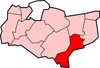
Shepway
Folkestone & Hythe, vroeger: Shepway, is een Engels district in het shire-graafschap (non-metropolitan county OF county) Kent en telt 113.000 inwoners. De oppervlakte bedraagt 357 km².
| Niet-metropolitaans district in Engeland | |||
  | |||
| Situering | |||
| Land | Engeland | ||
| County | Kent | ||
| Regio | South East England | ||
| Coördinaten | 51°4'44"NB, 1°10'29"OL | ||
| Algemeen | |||
| Oppervlakte | 356,7648[1] km² | ||
| Inwoners (2018[2]) | 112578 (316 inw./km²) | ||
| ONS-code | E07000112 | ||
| |||
Van de bevolking is 20,1% ouder dan 65 jaar. De werkloosheid bedraagt 3,4% van de beroepsbevolking (cijfers volkstelling 2001).
Civil parishes in district Folkestone & Hythe
Acrise, Brenzett, Brookland, Burmarsh, Dymchurch, Elham, Elmsted, Folkestone, Hawkinge, Hythe, Ivychurch, Lydd, Lyminge, Lympne, Monks Horton, New Romney, Newchurch, Newington, Old Romney, Paddlesworth, Postling, Saltwood, Sandgate, Sellindge, Snargate, St. Mary in the Marsh, Stanford, Stelling Minnis, Stowting, Swingfield.
| Bronnen, noten en/of referenties |
- Office for National Statistics → Download → SAM_for_Administrative_Areas_(2018).zip → SAM_LAD_DEC_2018_UK.xlsx.
- https://www.ons.gov.uk/file?uri=/peoplepopulationandcommunity/populationandmigration/populationestimates/datasets/populationestimatesforukenglandandwalesscotlandandnorthernireland/mid20182019laboundaries/ukmidyearestimates20182019ladcodes.xls Schatting Office for National Statistics: knop MYE5 → kolom Estimated Population mid-2018]
This article is issued from
Wikipedia.
The text is licensed under Creative
Commons - Attribution - Sharealike.
Additional terms may apply for the media files.