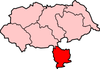
Selby (district)
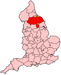
Selby is een Engels district in het shire-graafschap (non-metropolitan county OF county) North Yorkshire en telt 89.000 inwoners. De oppervlakte bedraagt 599 km². Hoofdplaats is Selby.
| Niet-metropolitaans district in Engeland | |||
  | |||
| Situering | |||
| Land | Engeland | ||
| County | North Yorkshire | ||
| Regio | Yorkshire and the Humber | ||
| Coördinaten | 53°46'37"NB, 1°4'44"WL | ||
| Algemeen | |||
| Oppervlakte | 599,3108[1] km² | ||
| Inwoners (2018[2]) | 89106 (149 inw./km²) | ||
| ONS-code | E07000169 | ||
| |||
Van de bevolking is 14,7% ouder dan 65 jaar. De werkloosheid bedraagt 2,5% van de beroepsbevolking (cijfers volkstelling 2001).
Civil parishes in district Selby
Acaster Selby, Appleton Roebuck, Balne, Barkston Ash, Barlby with Osgodby, Barlow, Beal, Biggin, Bilbrough, Birkin, Bolton Percy, Brayton, Brotherton, Burn, Burton Salmon, Byram cum Sutton, Camblesforth, Carlton, Catterton, Cawood, Chapel Haddlesey, Church Fenton, Cliffe, Colton, Cridling Stubbs, Drax, Eggborough, Escrick, Fairburn, Gateforth, Grimston, Hambleton, Healaugh, Heck, Hemingbrough, Hensall, Hillam, Hirst Courtney, Huddleston with Newthorpe, Kelfield, Kellington, Kirk Smeaton, Kirkby Wharfe with North Milford, Lead, Little Fenton, Little Smeaton, Long Drax, Monk Fryston, Newland, Newton Kyme cum Toulston, North Duffield, Oxton, Riccall, Ryther cum Ossendyke, Saxton with Scarthingwell, Selby, Sherburn in Elmet, Skipwith, South Milford, Stapleton, Steeton, Stillingfleet, Stutton with Hazlewood, Tadcaster, Temple Hirst, Thorganby, Thorpe Willoughby, Towton, Ulleskelf, Walden Stubbs, West Haddlesey, Whitley, Wistow, Womersley.
Bronnen, noten en/of referenties
|