Sedgemoor
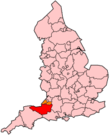
Sedgemoor is een Engels district in het shire-graafschap (non-metropolitan county OF county) Somerset en telt 123.000 inwoners. De oppervlakte bedraagt 564 km².
| Niet-metropolitaans district in Engeland | |||
  | |||
| Situering | |||
| Land | Engeland | ||
| County | Somerset | ||
| Regio | South West England | ||
| Coördinaten | 51°8'NB, 2°48'WL | ||
| Algemeen | |||
| Oppervlakte | 564,3577[1] km² | ||
| Inwoners (2018[2]) | 122791 (218 inw./km²) | ||
| ONS-code | E07000188 | ||
| |||
Van de bevolking is 19,1% ouder dan 65 jaar. De werkloosheid bedraagt 2,7% van de beroepsbevolking (cijfers volkstelling 2001).
Plaatsen in district Sedgemoor
Civil parishes in district Sedgemoor
Ashcott, Axbridge, Badgworth, Bawdrip, Berrow, Brean, Brent Knoll, Bridgwater, Bridgwater Without, Broomfield, Burnham Without, Burnham-on-Sea and Highbridge, Burtle, Cannington, Catcott, Chapel Allerton, Cheddar, Chedzoy, Chilton Polden, Chilton Trinity, Compton Bishop, Cossington, Durleigh, East Brent, East Huntspill, Edington, Enmore, Fiddington, Goathurst, Greinton, Lympsham, Lyng, Mark, Middlezoy, Moorlinch, Nether Stowey, North Petherton, Othery, Otterhampton, Over Stowey, Pawlett, Puriton, Shapwick, Shipham, Spaxton, Stawell, Stockland Bristol, Thurloxton, Weare, Wedmore, Wembdon, West Huntspill, Westonzoyland, Woolavington.
Bronnen, noten en/of referenties
|