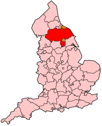
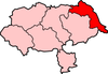
Scarborough (district)
Scarborough is een Engels district in het shire-graafschap (non-metropolitan county OF county) North Yorkshire en telt 109.000 inwoners. De oppervlakte bedraagt 816 km². Hoofdplaats is Scarborough.
| Niet-metropolitaans district in Engeland | |||
  | |||
| Situering | |||
| Land | Engeland | ||
| County | North Yorkshire | ||
| Regio | Yorkshire and the Humber | ||
| Coördinaten | 54°16'48"NB, 0°24'7"WL | ||
| Algemeen | |||
| Oppervlakte | 816,4871[1] km² | ||
| Inwoners (2018[2]) | 108736 (133 inw./km²) | ||
| ONS-code | E07000168 | ||
| |||
Van de bevolking is 21,4% ouder dan 65 jaar. De werkloosheid bedraagt 3,6% van de beroepsbevolking (cijfers volkstelling 2001).
Plaatsen in district Scarborough
Civil parishes in district Scarborough
Aislaby, Barnby, Borrowby, Brompton, Broxa-cum-Troutsdale, Burniston, Cayton, Cloughton, Commondale, Danby, Darncombe-cum-Langdale End, East Ayton, Eastfield, Egton, Ellerby, Eskdaleside cum Ugglebarnby, Filey, Folkton, Fylingdales, Glaisdale, Goathland, Gristhorpe, Grosmont, Hackness, Harwood Dale, Hawsker-cum-Stainsacre, Hinderwell, Hunmanby, Hutton Buscel, Hutton Mulgrave, Irton, Lands common to Fylingdales and Hawsker-cum-Stainsacre, Lebberston, Lythe, Mickleby, Muston, Newby and Scalby, Newholm-cum-Dunsley, Newton Mulgrave, Osgodby, Reighton, Roxby, Seamer, Silpho, Snainton, Sneaton, Stainton Dale, Suffield-cum-Everley, Ugthorpe, West Ayton, Westerdale, Whitby, Wykeham.
Bronnen, noten en/of referenties
|