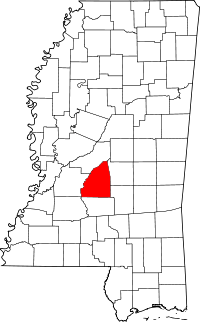
Rankin County
Rankin County is een county in de Amerikaanse staat Mississippi.
| County in de Verenigde Staten | |||
 | |||
| Situering | |||
| Staat | Mississippi | ||
| Coördinaten | 32°15'36"NB, 89°57'0"WL | ||
| Algemeen | |||
| Oppervlakte | 2.088 km² | ||
| - land | 2.006 km² | ||
| - water | 82 km² | ||
| Inwoners (2000) | 115.327 (57 inw./km²) | ||
| Overig | |||
| Zetel | Brandon | ||
| FIPS-code | 28121 | ||
| Opgericht | 1828 | ||
| Foto's | |||
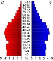 Bevolkingspiramide Rankin County | |||
| Statistieken volkstelling Rankin County | |||
| |||
De county heeft een landoppervlakte van 2.006 km² en telt 115.327 inwoners (volkstelling 2000). De hoofdplaats is Brandon.
Bevolkingsontwikkeling
| Historische inwonertallen | |||
|---|---|---|---|
| Jaar | Inwoners | % ± | |
| 1900 | 20.955 | ||
| 1910 | 23.944 | 14,3% | |
| 1920 | 20.272 | −15,3% | |
| 1930 | 20.353 | 0,4% | |
| 1940 | 27.934 | 37,2% | |
| 1950 | 28.881 | 3,4% | |
| 1960 | 34.322 | 18,8% | |
| 1970 | 43.933 | 28,0% | |
| 1980 | 69.427 | 58,0% | |
| 1990 | 87.161 | 25,5% | |
| 2000 | 115.327 | 32,3% | |
| Bron: (en) Historical Decennial Census Population | |||
This article is issued from
Wikipedia.
The text is licensed under Creative
Commons - Attribution - Sharealike.
Additional terms may apply for the media files.