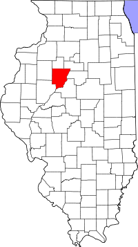
Peoria County
Peoria County is een county in de Amerikaanse staat Illinois.
| County in de Verenigde Staten | |||
 | |||
| Situering | |||
| Staat | Illinois | ||
| Coördinaten | 40°47'24"NB, 89°45'36"WL | ||
| Algemeen | |||
| Oppervlakte | 1.634 km² | ||
| - land | 1.605 km² | ||
| - water | 29 km² | ||
| Inwoners (2000) | 183.433 (114 inw./km²) | ||
| Overig | |||
| Zetel | Peoria | ||
| FIPS-code | 17143 | ||
| Opgericht | 1825 | ||
| Foto's | |||
| Statistieken volkstelling Peoria County | |||
| |||
De county heeft een landoppervlakte van 1.605 km² en telt 183.433 inwoners (volkstelling 2000). De hoofdplaats is Peoria.
Bevolkingsontwikkeling
| Historische inwonertallen | |||
|---|---|---|---|
| Jaar | Inwoners | % ± | |
| 1900 | 88.608 | ||
| 1910 | 100.255 | 13,1% | |
| 1920 | 111.710 | 11,4% | |
| 1930 | 141.344 | 26,5% | |
| 1940 | 153.374 | 8,5% | |
| 1950 | 174.347 | 13,7% | |
| 1960 | 189.044 | 8,4% | |
| 1970 | 195.318 | 3,3% | |
| 1980 | 200.466 | 2,6% | |
| 1990 | 182.827 | −8,8% | |
| 2000 | 183.433 | 0,3% | |
| Bron: (en) Historical Decennial Census Population | |||
This article is issued from
Wikipedia.
The text is licensed under Creative
Commons - Attribution - Sharealike.
Additional terms may apply for the media files.