Oneida County (Idaho)
Oneida County is een county in de Amerikaanse staat Idaho.
| County in de Verenigde Staten | |||
 | |||
| Situering | |||
| Staat | Idaho | ||
| Coördinaten | 42°12'36"NB, 112°31'12"WL | ||
| Algemeen | |||
| Oppervlakte | 3.112 km² | ||
| - land | 3.109 km² | ||
| - water | 3 km² | ||
| Inwoners (2000) | 4.125 (1 inw./km²) | ||
| Overig | |||
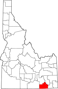
| Zetel | Malad City | ||
| FIPS-code | 16071 | ||
| Opgericht | 1864 | ||
| Foto's | |||
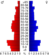 Bevolkingspiramide Oneida County | |||
| Statistieken volkstelling Oneida County | |||
| |||
De county heeft een landoppervlakte van 3.109 km² en telt 4.125 inwoners (volkstelling 2000). De hoofdplaats is Malad City.
Bevolkingsontwikkeling
| Historische inwonertallen | |||
|---|---|---|---|
| Jaar | Inwoners | % ± | |
| 1900 | 8.933 | ||
| 1910 | 15.170 | 69,8% | |
| 1920 | 6.723 | −55,7% | |
| 1930 | 5.870 | −12,7% | |
| 1940 | 5.417 | −7,7% | |
| 1950 | 4.387 | −19,0% | |
| 1960 | 3.603 | −17,9% | |
| 1970 | 2.864 | −20,5% | |
| 1980 | 3.258 | 13,8% | |
| 1990 | 3.492 | 7,2% | |
| 2000 | 4.125 | 18,1% | |
| Bron: (en) Historical Decennial Census Population | |||
This article is issued from
Wikipedia.
The text is licensed under Creative
Commons - Attribution - Sharealike.
Additional terms may apply for the media files.