Morris County (Kansas)
Morris County is een county in de Amerikaanse staat Kansas.
| County in de Verenigde Staten | |||
 | |||
| Situering | |||
| Staat | Kansas | ||
| Coördinaten | 38°42'NB, 96°36'WL | ||
| Algemeen | |||
| Oppervlakte | 1.820 km² | ||
| - land | 1.806 km² | ||
| - water | 14 km² | ||
| Inwoners (2000) | 6.104 (3 inw./km²) | ||
| Overig | |||
| Zetel | Council Grove | ||
| FIPS-code | 20127 | ||
| Opgericht | 1859 | ||
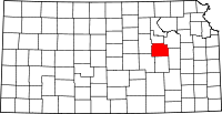
| Detailkaart | |||
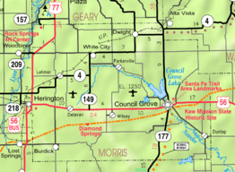 | |||
| Overzichtskaart van Morris County | |||
| Foto's | |||
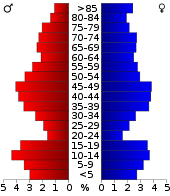 Bevolkingspiramide Morris County | |||
| Statistieken volkstelling Morris County | |||
| |||
De county heeft een landoppervlakte van 1.806 km² en telt 6.104 inwoners (volkstelling 2000). De hoofdplaats is Council Grove.
Bevolkingsontwikkeling
| Historische inwonertallen | |||
|---|---|---|---|
| Jaar | Inwoners | % ± | |
| 1900 | 11.967 | ||
| 1910 | 12.397 | 3,6% | |
| 1920 | 12.005 | −3,2% | |
| 1930 | 11.859 | −1,2% | |
| 1940 | 10.363 | −12,6% | |
| 1950 | 8.485 | −18,1% | |
| 1960 | 7.392 | −12,9% | |
| 1970 | 6.432 | −13,0% | |
| 1980 | 6.419 | −0,2% | |
| 1990 | 6.198 | −3,4% | |
| 2000 | 6.104 | −1,5% | |
| Bron: (en) Historical Decennial Census Population | |||
This article is issued from
Wikipedia.
The text is licensed under Creative
Commons - Attribution - Sharealike.
Additional terms may apply for the media files.