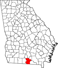
Lowndes County (Georgia)
Lowndes County is een county in de Amerikaanse staat Georgia.
| County in de Verenigde Staten | |||
 | |||
| Situering | |||
| Staat | Georgia | ||
| Coördinaten | 30°49'48"NB, 83°16'12"WL | ||
| Algemeen | |||
| Oppervlakte | 1.323 km² | ||
| - land | 1.306 km² | ||
| - water | 17 km² | ||
| Inwoners (2000) | 92.115 (71 inw./km²) | ||
| Overig | |||
| Zetel | Valdosta | ||
| FIPS-code | 13185 | ||
| Opgericht | 1825 | ||
| Foto's | |||
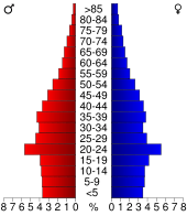 Bevolkingspiramide Lowndes County | |||
| Statistieken volkstelling Lowndes County | |||
| |||
De county heeft een landoppervlakte van 1.306 km² en telt 92.115 inwoners (volkstelling 2000). De hoofdplaats is Valdosta.
Bevolkingsontwikkeling
| Historische inwonertallen | |||
|---|---|---|---|
| Jaar | Inwoners | % ± | |
| 1900 | 20.036 | ||
| 1910 | 24.436 | 22,0% | |
| 1920 | 26.521 | 8,5% | |
| 1930 | 29.994 | 13,1% | |
| 1940 | 31.860 | 6,2% | |
| 1950 | 35.211 | 10,5% | |
| 1960 | 49.270 | 39,9% | |
| 1970 | 55.112 | 11,9% | |
| 1980 | 67.972 | 23,3% | |
| 1990 | 75.981 | 11,8% | |
| 2000 | 92.115 | 21,2% | |
| Bron: (en) Historical Decennial Census Population | |||
This article is issued from
Wikipedia.
The text is licensed under Creative
Commons - Attribution - Sharealike.
Additional terms may apply for the media files.