Lijst van rijksmonumenten in de Wijk
De plaats de Wijk telt 29 inschrijvingen in het rijksmonumentenregister. Hieronder een overzicht. Zie ook de Lijst van rijksmonumenten in De Wolden.
| Object |
Oorspronkelijke functie? |
Bouwjaar |
Architect |
Locatie |
Coördinaten? | Nr.? |
Afbeelding |
|---|---|---|---|---|---|---|---|
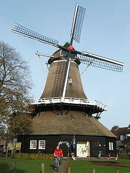
| De Wieker Meule | 1829 1980 (rest.)[2] |
Dorpsstraat 65 | 52° 40' 22" NB, 6° 17' 14" OL | 39657 Dit rijksmonument op Wikidata |
|||
| Voorhuis van voormalige boerderij | 1800-1850 | Commissieweg 40 | 52° 40' 13" NB, 6° 20' 8" OL | 39658 Dit rijksmonument op Wikidata |
 Voorhuis van voormalige boerderij | ||
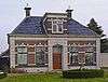
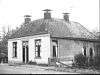
| Voorm. grutterij | mog. 18e eeuw (kern)[3] | Prof. Blinkweg 5 | 52° 40' 21" NB, 6° 16' 56" OL | 39659 Dit rijksmonument op Wikidata |
 Voorm. grutterij | ||
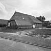
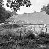
| Daglonershuisje met houten staldeel onder pannengedekt schilddak | ca. 1890[3] | Stapelerweg 12 | 52° 39' 52" NB, 6° 19' 56" OL | 47037 Dit rijksmonument op Wikidata |
 Daglonershuisje met houten staldeel onder pannengedekt schilddak | ||
| Boerderij in ambachtelijk-traditionele stijl met aangebouwde staart en ouderwoning | ca. 1860 ca. 1890 (ouderwoning) |
Stapelerweg 21 | 52° 39' 52" NB, 6° 19' 59" OL | 507394 Dit rijksmonument op Wikidata |
 Boerderij in ambachtelijk-traditionele stijl met aangebouwde staart en ouderwoning | ||
| Boerderij in eclectische stijl met dwarsgebouwd voorhuis, achterhuis, schuur en aangebouwde schuur | 1905[5] | Commissieweg 7 | 52° 40' 24" NB, 6° 18' 4" OL | 507395 Dit rijksmonument op Wikidata |
 Boerderij in eclectische stijl met dwarsgebouwd voorhuis, achterhuis, schuur en aangebouwde schuur | ||
| Dickninge, dubbele dienstwoning | ca. 1885[3] 1996 (schuur) |
Schiphorsterweg 44-46 | 52° 40' 11" NB, 6° 16' 29" OL | 507397 Dit rijksmonument op Wikidata |
Upload foto | ||
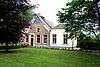
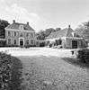
| Dickninge, hoofdgebouw | 1813 ca. 1860 (serre) |
Schiphorsterweg 40 | 52° 40' 5" NB, 6° 16' 27" OL | 513964 Dit rijksmonument op Wikidata |
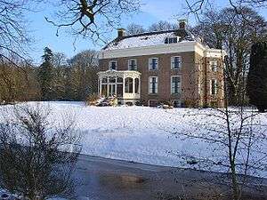 Dickninge, hoofdgebouw | ||
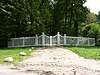
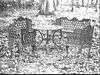
| Dickninge, toegangshek | 1817 | bij Schiphorsterweg 38 t/m 46 | 52° 40' 23" NB, 6° 16' 21" OL | 513968 Dit rijksmonument op Wikidata |
Upload foto | ||
| Dickninge, houten hek | oorspr. 19e eeuw | bij Schiphorsterweg 44-46 | 52° 40' 11" NB, 6° 16' 27" OL | 513969 Dit rijksmonument op Wikidata |
 Dickninge, houten hek | ||
| Dickninge, toegangsbrug | ca. 1867 | bij Schiphorsterweg 44-46 | 52° 40' 12" NB, 6° 16' 25" OL | 513970 Dit rijksmonument op Wikidata |
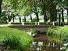 Dickninge, toegangsbrug | ||
| Dickninge, dubbele dienstwoning | ca. 1885[3] 1996 (schuur) |
Schiphorsterweg 44-46 | 52° 40' 11" NB, 6° 16' 29" OL | 513971 Dit rijksmonument op Wikidata |
Upload foto | ||
| Dickninge, boerderij annex koetshuis (Het Bouwhuis) |
vroege 19e eeuw | Schiphorsterweg 42 | 52° 40' 6" NB, 6° 16' 31" OL | 513972 Dit rijksmonument op Wikidata |
 Dickninge, boerderij annex koetshuis (Het Bouwhuis) | ||
| Dickninge, ijskelder | middeleeuwen[7] 1813 (verb. tot ijskelder) |
bij Schiphorsterweg 40-42 | 52° 40' 4" NB, 6° 16' 31" OL | 513973 Dit rijksmonument op Wikidata |
Upload foto | ||
| Dickninge, moestuinmuur | vroege 19e eeuw | bij Schiphorsterweg 42 | 52° 40' 7" NB, 6° 16' 33" OL | 513974 Dit rijksmonument op Wikidata |
Upload foto | ||
| Dickninge, zonnewijzersokkel | 19e eeuw | bij Schiphorsterweg 40 | 52° 40' 4" NB, 6° 16' 27" OL | 513975 Dit rijksmonument op Wikidata |
Upload foto | ||
| Dickninge, houten brug | in aanleg verm. 1800-1850 | bij Schiphorsterweg 38-40 | 52° 40' 3" NB, 6° 16' 26" OL | 513976 Dit rijksmonument op Wikidata |
 Dickninge, houten brug | ||
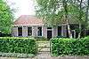
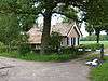
| Dickninge, tuinmanswoning | 19e eeuw | Schiphorsterweg 38 | 52° 40' 2" NB, 6° 16' 24" OL | 513977 Dit rijksmonument op Wikidata |
 Dickninge, tuinmanswoning | ||
| Dickninge, tolwoning met tolhek | ca. 1860[3] | Staphorsterweg 1 | 52° 40' 7" NB, 6° 15' 60" OL | 513978 Dit rijksmonument op Wikidata |
 Dickninge, tolwoning met tolhek | ||
| Dickninge, tolwoning met tolhek | ca. 1860[3] | Staphorsterweg 1 | 52° 40' 7" NB, 6° 15' 60" OL | 513978 Dit rijksmonument op Wikidata |
Dickninge, tolwoning met tolhek | ||
| Dickninge, Boerderij 't Hogeland | ca. 1600 | Staphorsterweg bij 2 | 52° 40' 20" NB, 6° 16' 5" OL | 513996 Dit rijksmonument op Wikidata |
Upload foto | ||
| Dickninge, houten stuw | 1458 of eerder (eerste vermelding stuwrecht) | bij Schiphorsterweg 38-40 | 52° 39' 60" NB, 6° 16' 28" OL | 520597 Dit rijksmonument op Wikidata |
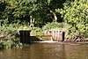 Dickninge, houten stuw | ||
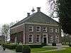
| Huis Voorwijk | 1791-'91[3] | Dorpsstraat 4 | 52° 40' 19" NB, 6° 16' 43" OL | 529556 Dit rijksmonument op Wikidata |
|||
| Voorwijk, tuin- en parkaanleg | Dorpsstraat bij 4 | 52° 40' 24" NB, 6° 16' 41" OL | 529557 Dit rijksmonument op Wikidata |
 Voorwijk, tuin- en parkaanleg | |||
| Voorwijk, linker bouwhuis | 1789-1792 | Dorpsstraat bij 4 | 52° 40' 19" NB, 6° 16' 43" OL | 529558 Dit rijksmonument op Wikidata |
Upload foto | ||
| Voorwijk, rechter bouwhuis | 1789-1792 | Dorpsstraat bij 4 | 52° 40' 19" NB, 6° 16' 43" OL | 529559 Dit rijksmonument op Wikidata |
 Voorwijk, rechter bouwhuis | ||
| Voorwijk, linker tuinmuur | Dorpsstraat bij 4 | 52° 40' 19" NB, 6° 16' 43" OL | 529560 Dit rijksmonument op Wikidata |
Upload foto | |||
| Voorwijk, rechter tuinmuur | Dorpsstraat bij 4 | 52° 40' 19" NB, 6° 16' 43" OL | 529561 Dit rijksmonument op Wikidata |
Upload foto | |||
| Voorwijk, twee piëdestals met vaas | eind 19e eeuw | Dorpsstraat bij 4 | 52° 40' 19" NB, 6° 16' 43" OL | 529562 Dit rijksmonument op Wikidata |
Upload foto |

Bronnen, noten en/of referenties
|
| Zie de categorie Rijksmonumenten in de Wijk van Wikimedia Commons voor mediabestanden over dit onderwerp. |
This article is issued from
Wikipedia.
The text is licensed under Creative
Commons - Attribution - Sharealike.
Additional terms may apply for the media files.