Lijst van rijksmonumenten in Voorst (plaats)
De plaats Voorst telt 51 inschrijvingen in het rijksmonumentenregister. Hieronder een overzicht.
| Object |
Oorspronkelijke functie? |
Bouwjaar |
Architect |
Locatie |
Coördinaten? | Nr.? |
Afbeelding |
|---|---|---|---|---|---|---|---|
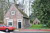
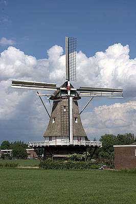
| De Zwaan | 1904 | Enkweg 44 | 52° 10' 4" NB, 6° 8' 9" OL | 38035 Dit rijksmonument op Wikidata |
|||
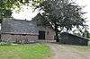
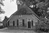
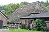
| Het Hoen | 1667 | Hoenweg 9 | 52° 10' 2" NB, 6° 9' 39" OL | 38036 Dit rijksmonument op Wikidata |
 Het Hoen | ||
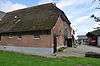
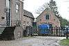
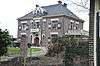
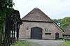
| De Keizershof | 18e eeuw | Keizershofweg 3 | 52° 10' 13" NB, 6° 8' 53" OL | 38037 Dit rijksmonument op Wikidata |
 De Keizershof | ||
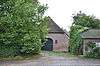
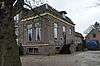
| Groot-Oerink | laat 19e eeuw | Kerkstraat 29 | 52° 10' 17" NB, 6° 8' 51" OL | 38038 Dit rijksmonument op Wikidata |
 Groot-Oerink | ||
| Slot Nijenbeek | 14e eeuw | Nijenbeekseweg | 52° 11' 12" NB, 6° 9' 42" OL | 38039 Dit rijksmonument op Wikidata |
|||
| Pandje, bestaande uit begane-grond met zadeldak tussen puntgevels | vroeg 19e eeuw | Rijksstraatweg 34 | 52° 10' 35" NB, 6° 8' 24" OL | 38041 Dit rijksmonument op Wikidata |
 Pandje, bestaande uit begane-grond met zadeldak tussen puntgevels | ||
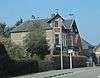
| Enkstein | derde kwart 19e eeuw | Rijksstraatweg 102 | 52° 10' 11" NB, 6° 8' 32" OL | 38042 Dit rijksmonument op Wikidata |
 Enkstein | ||
| De Adelaar | laat 16e eeuw | Rijksstraatweg 49 | 52° 10' 39" NB, 6° 8' 28" OL | 38043 Dit rijksmonument op Wikidata |
|||
| Nederlands hervormde kerk | 15e eeuw | Schoolstraat 16 | 52° 10' 16" NB, 6° 8' 52" OL | 38044 Dit rijksmonument op Wikidata |
|||
| Toren der hervormde kerk | 12e eeuw | Schoolstraat bij 16 | 52° 10' 16" NB, 6° 8' 52" OL | 38045 Dit rijksmonument op Wikidata |
 Toren der hervormde kerk | ||
| Sinderen | vroeg 19e eeuw | Voorsterklei 9 | 52° 10' 21" NB, 6° 10' 1" OL | 38046 Dit rijksmonument op Wikidata |
|||
| De Rageboom | eerste kwart 19e eeuw | Wilhelminaweg 16 | 52° 10' 18" NB, 6° 8' 38" OL | 38047 Dit rijksmonument op Wikidata |
 De Rageboom | ||
| Weerdshuisje | vroeg 19e eeuw | Deventerweg 44 | 52° 11' 6" NB, 6° 8' 2" OL | 38051 Dit rijksmonument op Wikidata |
 Weerdshuisje | ||
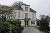
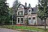
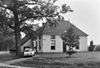
| Huize Kerkzicht: villa | 1850-1860 | Rijksstraatweg 100 | 52° 10' 14" NB, 6° 8' 31" OL | 523339 Dit rijksmonument op Wikidata |
 Huize Kerkzicht: villa | ||
| Huize Kerkzicht: koetshuis | 1850-1860 | Rijksstraatweg bij 100 | 52° 10' 14" NB, 6° 8' 31" OL | 523340 Dit rijksmonument op Wikidata |
 Huize Kerkzicht: koetshuis | ||
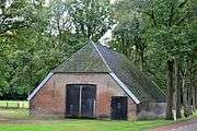
| Kleine zaalkerk | 1875-1880 | Enkweg 1 | 52° 10' 7" NB, 6° 8' 35" OL | 523351 Dit rijksmonument op Wikidata |
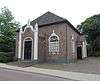 Kleine zaalkerk | ||
| Ruimzicht | 1917 | Rijksstraatweg 69 | 52° 10' 17" NB, 6° 8' 34" OL | 523352 Dit rijksmonument op Wikidata |
 Ruimzicht | ||
| Klein Wiarda State | 1909 | Rijksstraatweg 72 | 52° 10' 22" NB, 6° 8' 29" OL | 523353 Dit rijksmonument op Wikidata |
 Klein Wiarda State | ||
| 'De Hoek/De Goede Reede' | 1900-1910 | Schoolstraat 25 | 52° 10' 13" NB, 6° 8' 45" OL | 523354 Dit rijksmonument op Wikidata |
 'De Hoek/De Goede Reede' | ||
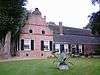
| De Poll | 16e eeuw (eerste vermelding) | Poll-laan 5 | 52° 12' 1" NB, 6° 8' 38" OL | 530073 Dit rijksmonument op Wikidata |
|||
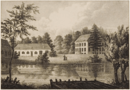
| De Poll: historische tuin- en parkaanleg | 1783 (eerste vermelding) | Poll-laan bij 5 | 52° 11' 37" NB, 6° 8' 20" OL | 530074 Dit rijksmonument op Wikidata |
Upload foto | ||
| De Poll: paardenstal | midden 19e eeuw | Poll-laan bij 5 | 52° 11' 53" NB, 6° 8' 35" OL | 530075 Dit rijksmonument op Wikidata |
Upload foto | ||
| De Poll: tuinmanswoning | 1898 | Poll-laan 2 | 52° 11' 48" NB, 6° 8' 33" OL | 530076 Dit rijksmonument op Wikidata |
 De Poll: tuinmanswoning | ||
| De Poll: werkschuur | midden 19e eeuw | Poll-laan bij 5 | 52° 11' 54" NB, 6° 8' 33" OL | 530077 Dit rijksmonument op Wikidata |
Upload foto | ||
| De Poll: houten loods | eerste kwart 20e eeuw | Poll-laan bij 5 | 52° 11' 54" NB, 6° 8' 33" OL | 530078 Dit rijksmonument op Wikidata |
Upload foto | ||
| De Poll: moesttuinmuur met kas | 1844 (eerste vermelding) | Poll-laan bij 5 | 52° 11' 51" NB, 6° 8' 33" OL | 530079 Dit rijksmonument op Wikidata |
Upload foto | ||
| De Poll: koude bakken | ca. 1900 | Poll-laan bij 5 | 52° 11' 52" NB, 6° 8' 35" OL | 530080 Dit rijksmonument op Wikidata |
Upload foto | ||
| De Poll: de oude poll | 1696 (jaartalanker) | Deventerweg 1 | 52° 12' 7" NB, 6° 8' 36" OL | 530081 Dit rijksmonument op Wikidata |
Upload foto | ||
| De Poll: de zutphenboer | 1783 (eerste vermelding) | Deventerweg 3 | 52° 12' 15" NB, 6° 8' 14" OL | 530082 Dit rijksmonument op Wikidata |
Upload foto | ||
| De Poll: landbouwschuur bij de zutphenboer | Deventerweg bij 3 | 52° 12' 16" NB, 6° 8' 14" OL | 530083 Dit rijksmonument op Wikidata |
Upload foto | |||
| De Poll: de bremte | 1783 (eerste vermelding) | Deventerweg 4 | 52° 12' 12" NB, 6° 7' 51" OL | 530084 Dit rijksmonument op Wikidata |
Upload foto | ||
| De Poll: landbouwschuur bij de bremte | 19e eeuw | Deventerweg bij 4 | 52° 12' 13" NB, 6° 7' 51" OL | 530085 Dit rijksmonument op Wikidata |
Upload foto | ||
| De Poll: hof te gietel | Deventerweg 13 | 52° 11' 40" NB, 6° 7' 55" OL | 530086 Dit rijksmonument op Wikidata |
 De Poll: hof te gietel | |||
| De Poll: landbouwschuur bij hof te gietel | eerste helft 19e eeuw | Deventerweg bij 13 | 52° 11' 40" NB, 6° 7' 56" OL | 530087 Dit rijksmonument op Wikidata |
 De Poll: landbouwschuur bij hof te gietel | ||
| De Poll: bakhuisje bij hof te gietel | 19e eeuw | Deventerweg bij 13 | 52° 11' 40" NB, 6° 7' 55" OL | 530088 Dit rijksmonument op Wikidata |
Upload foto | ||
| De Poll: de stakenberg | tweede helft 19e eeuw | Deventerweg 20 | 52° 11' 37" NB, 6° 7' 42" OL | 530089 Dit rijksmonument op Wikidata |
 De Poll: de stakenberg | ||
| De Poll: landbouwschuur bij de stakenberg | tweede helft 19e eeuw | Deventerweg bij 20 | 52° 11' 37" NB, 6° 7' 42" OL | 530090 Dit rijksmonument op Wikidata |
Upload foto | ||
| De Poll: de gietelsche brouwerij | 19e eeuw en ouder | Deventerweg 28 | 52° 11' 29" NB, 6° 7' 43" OL | 530091 Dit rijksmonument op Wikidata |
 De Poll: de gietelsche brouwerij | ||
| De Poll: portierswoning | tweede helft 19e eeuw | Deventerweg 17 | 52° 11' 29" NB, 6° 7' 46" OL | 530092 Dit rijksmonument op Wikidata |
 De Poll: portierswoning | ||
| De Poll: de hoek | eerste helft 19e eeuw | Deventerweg 30 | 52° 11' 24" NB, 6° 7' 44" OL | 530093 Dit rijksmonument op Wikidata |
Upload foto | ||
| De Poll: hof te praesink | 1938 | Deventerweg 19 | 52° 11' 27" NB, 6° 7' 58" OL | 530094 Dit rijksmonument op Wikidata |
Upload foto | ||
| De Poll: landbouwschuur bij hof te praesink | Deventerweg bij 19 | 52° 11' 27" NB, 6° 7' 59" OL | 530095 Dit rijksmonument op Wikidata |
Upload foto | |||
| De Poll: belle rensink | tweede helft 19e eeuw | Deventerweg 21 | 52° 11' 19" NB, 6° 7' 53" OL | 530096 Dit rijksmonument op Wikidata |
Upload foto | ||
| De Poll: landbouwschuur bij belle rensink | eerste helft 19e eeuw | Deventerweg bij 21 | 52° 11' 20" NB, 6° 7' 53" OL | 530097 Dit rijksmonument op Wikidata |
Upload foto | ||
| De Poll: winterakkers | 1850-1860 | Deventerweg 23 | 52° 11' 15" NB, 6° 8' 6" OL | 530098 Dit rijksmonument op Wikidata |
Upload foto | ||
| De Poll: de korte bree | tweede helft 19e eeuw | Deventerweg 27 | 52° 11' 13" NB, 6° 8' 5" OL | 530099 Dit rijksmonument op Wikidata |
Upload foto | ||
| De Poll: bakhuisje bij de korte bree | Deventerweg bij 27 | 52° 11' 12" NB, 6° 8' 5" OL | 530100 Dit rijksmonument op Wikidata |
Upload foto | |||
| De Poll: kozakkenhut | 1805 (eerste vermelding) | Poll-laan bij 5 | 52° 12' 9" NB, 6° 8' 18" OL | 530101 Dit rijksmonument op Wikidata |
Upload foto | ||
| De Poll: zonnewijzer | 18e eeuw | Poll-laan bij 5 | 52° 11' 58" NB, 6° 8' 40" OL | 530102 Dit rijksmonument op Wikidata |
Upload foto | ||
| De Poll: landbouwschuur bij de portierswoning | 1898 | Deventerweg bij 17 | 52° 11' 29" NB, 6° 7' 45" OL | 530131 Dit rijksmonument op Wikidata |
 De Poll: landbouwschuur bij de portierswoning | ||
| De Poll: pijlers | 19e eeuw | Poll-laan bij 5 | 52° 12' 8" NB, 6° 8' 5" OL | 530132 Dit rijksmonument op Wikidata |
Upload foto |
.jpg)
.jpg)

Zie ook
- Lijst van rijksmonumenten in Voorst (gemeente) voor andere plaatsen in de gemeente.
| Zie de categorie Rijksmonumenten in Voorst, Gelderland van Wikimedia Commons voor mediabestanden over dit onderwerp. |
| Bronnen, noten en/of referenties |
This article is issued from
Wikipedia.
The text is licensed under Creative
Commons - Attribution - Sharealike.
Additional terms may apply for the media files.