Lijst van gemeentelijke monumenten in Borne
De gemeente Borne telt 47 gemeentelijke monumenten, hieronder een overzicht. Zie ook de rijksmonumenten in Borne.
Borne
De plaats Borne kent 39 gemeentelijke monumenten:
| Object | Bouwjaar | Architect | Locatie | Coördinaten | Nr. | Afbeelding |
|---|---|---|---|---|---|---|
| Dubbele woning | Aanslagsweg / Grotestraat 53/129 | 52° 17' 41" NB, 6° 45' 45" OL | 0147/1 | 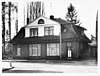 | ||
| Dubbele woning | Azelosestraat 50/52 | 52° 18' 2" NB, 6° 44' 43" OL | 0147/2 | Upload foto | ||
| Woningblok (3 woningen) | Brinkstraat 13-17 | 52° 18' 4" NB, 6° 45' 39" OL | 0147/3 | 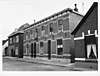 | ||
| Woning/bedrijf | Brinkstraat 16 | 52° 18' 3" NB, 6° 45' 37" OL | 0147/4 | Upload foto | ||
| Woning | Brinkstraat 35/37 | 52° 18' 2" NB, 6° 45' 39" OL | 0147/5 | Upload foto | ||
| Winkel/woning | Brinkstraat 6 | 52° 18' 5" NB, 6° 45' 37" OL | 0147/6 | Upload foto | ||
| Erve De Lemerij | Burenweg 70 | 52° 17' 10" NB, 6° 45' 6" OL | 0147/B05 | Upload foto | ||
| Herenhuis | Deldensestraat 5 | 52° 17' 46" NB, 6° 44' 52" OL | 0147/7 | 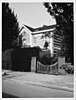 | ||
| Herenhuis | Deldensestraat 7 | 52° 17' 45" NB, 6° 44' 51" OL | 0147/8 | 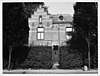 | ||
| Erve Wildijk | (bij) Deurningerweg 1/3 | 0147/B07 | Upload foto | |||
| De Keizerskroon | Dorsetplein 3 | 52° 18' 5" NB, 6° 45' 27" OL | 0147/9 | .JPG) | ||
| Voormalig Sint Josephgebouw | Ennekerdijk 10 | 52° 17' 56" NB, 6° 45' 40" OL | 0147/10 | 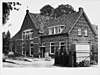 | ||
| Het Oude Schip | Ennekerdijk 38 | 52° 18' 1" NB, 6° 45' 43" OL | 0147/11 | Upload foto | ||
| Roeselinghuis | Ennekerdijk 9 | 52° 17' 57" NB, 6° 45' 38" OL | 0147/12 | Upload foto | ||
| Pand scouting St. Martina | Esstraat 3 | 52° 18' 5" NB, 6° 45' 16" OL | 0147/13 | Upload foto | ||
| Dubbele woning | Grotestraat 131/133 | 52° 17' 54" NB, 6° 45' 35" OL | 0147/14 | 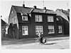 | ||
| Dubbele woning | Grotestraat 135/137 | 52° 17' 55" NB, 6° 45' 35" OL | 0147/15 |  | ||
| Pand bakkerij Immerman | Grotestraat 172 | 52° 18' 6" NB, 6° 45' 22" OL | 0147/16 | Upload foto | ||
| Dubbele winkel/woning | Grotestraat 176/178 | 52° 18' 6" NB, 6° 45' 21" OL | 0147/17 | 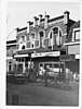 | ||
| Huis van Vledder | Grotestraat 246/248 | 52° 18' 6" NB, 6° 45' 6" OL | 0147/18 | 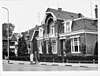 | ||
| Het Koetshuis | Grotestraat 260 | 52° 18' 8" NB, 6° 45' 3" OL | 0147/19 | 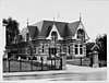 | ||
| Het Witte Huis | Grotestraat 262 | 52° 18' 8" NB, 6° 45' 3" OL | 0147/20 | 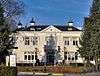 | ||
| Herenhuis | Grotestraat 264 | 52° 18' 9" NB, 6° 45' 1" OL | 0147/21 | 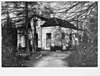 | ||
| Erve Engberink – Broekhuis | Hedeveldsweg 11 | 52° 18' 44" NB, 6° 45' 18" OL | 0147/B06 | Upload foto | ||
| Mariakapel | Koppelsbrink (ong.) | 0147/23 | .jpg) | |||
| Woning | Koppelsbrink 44/46 | 52° 18' 8" NB, 6° 45' 38" OL | 0147/24 | Upload foto | ||
| Vrml. Arbeiderswoningen | Koppelsbrink 50/52 | 52° 18' 7" NB, 6° 45' 37" OL | 0147/25 | Upload foto | ||
| Huis Homan | Koppelsbrink 8 | 52° 18' 7" NB, 6° 45' 39" OL | 0147/26 | Upload foto | ||
| Vrml. Pastorie Herv. Gemeente | Markstraat 23 | 52° 18' 8" NB, 6° 45' 29" OL | 0147/27 | Upload foto | ||
| De Oude Smederij | Meijershof 41277 | 52° 18' 5" NB, 6° 45' 42" OL | 0147/28 | Upload foto | ||
| Klompenmakershuis | Meijershof 2 | 52° 18' 2" NB, 6° 45' 44" OL | 0147/29 | Upload foto | ||
| Gem. begraafplaats | Oude Almeloseweg (ong.) | 52° 18' 15" NB, 6° 45' 4" OL | 0147/31 | 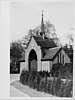 | ||
| Kosterij | Oude Kerkstraat 4 | 52° 18' 2" NB, 6° 45' 34" OL | 0147/32 | Upload foto | ||
| O.a. De Harmonie | Potkampstraat 2 / Grotestraat | 52° 17' 39" NB, 6° 45' 54" OL | 0147/33 | Upload foto | ||
| Het dokter Stompshuis | Prins Bernhardlaan 23 | 52° 18' 10" NB, 6° 44' 54" OL | 0147/34 | Upload foto | ||
| Vrml. Bedrijfspand Spanjaard | Stationsstraat 37 | 52° 17' 54" NB, 6° 45' 3" OL | 0147/35 | Upload foto | ||
| Dubbele woning | Stationsstraat 52/54 | 52° 17' 56" NB, 6° 45' 9" OL | 0147/36 | 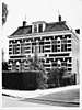 | ||
| Erve Mösselboer | Watertorenstraat 13 | 52° 18' 1" NB, 6° 45' 45" OL | 0147/37 | Upload foto | ||
| Watertoren | Watertorenstraat 28 | 52° 17' 57" NB, 6° 45' 49" OL | 0147/38 |  |
Hertme
De plaats Hertme kent 4 gemeentelijke monumenten:
| Object | Bouwjaar | Architect | Locatie | Coördinaten | Nr. | Afbeelding |
|---|---|---|---|---|---|---|
| Erve de Greve | Aalderinksweg 2 | 52° 18' 36" NB, 6° 46' 1" OL | 0147/B01 | Upload foto | ||
| Theekoepel Erve de Greve | (bij) Aalderinksweg 2 | 0147/B02 | Upload foto | |||
| R.K. St. Stephanuskerk | Hertmerweg 27 | 52° 19' 12" NB, 6° 45' 33" OL | 0147/22 | 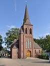 | ||
| Pompstation Spanjaard | Veldhuisweg 1a | 52° 18' 37" NB, 6° 46' 21" OL | 0147/B10 | Upload foto |
Zenderen
De plaats Zenderen kent 4 gemeentelijke monumenten:
| Object | Bouwjaar | Architect | Locatie | Coördinaten | Nr. | Afbeelding |
|---|---|---|---|---|---|---|
| Erve Oude Egberink | Albergerweg 17 | 52° 19' 49" NB, 6° 43' 33" OL | 0147/B04 | Upload foto | ||
| Erve Egberink of Eyminck | Albergerweg 22 | 52° 19' 44" NB, 6° 43' 40" OL | 0147/B09 | Upload foto | ||
| Erve Hilbrink | Hilbertsweg 2 | 52° 18' 54" NB, 6° 44' 23" OL | 0147/B08 | Upload foto | ||
| Boerderij ‘De Zeilker’ | Lidwinaweg 46B | 52° 19' 12" NB, 6° 43' 14" OL | 0147/B11 | Upload foto |
Bronnen, noten en/of referenties
|
| Gemeentelijke monumenten in Overijssel | ||
|---|---|---|
|
Almelo · Borne · Dalfsen · Dinkelland · Deventer · Enschede · Haaksbergen · Hardenberg · Hellendoorn · Hengelo · Hof van Twente · Kampen · Losser · Oldenzaal · Olst-Wijhe · Ommen · Raalte · Rijssen-Holten · Staphorst · Steenwijkerland · Twenterand · Wierden · Zwartewaterland · Zwolle | ||
| Zie de categorie Gemeentelijke monumenten in Borne, Netherlands van Wikimedia Commons voor mediabestanden over dit onderwerp. |
This article is issued from
Wikipedia.
The text is licensed under Creative
Commons - Attribution - Sharealike.
Additional terms may apply for the media files.