Lijst van gemeentelijke monumenten in Grave (gemeente)
De gemeente Grave heeft 111 gemeentelijke monumenten, hieronder een overzicht. Zie ook de rijksmonumenten in Grave.
Escharen
De plaats Escharen kent 11 gemeentelijke monumenten:
| Object | Bouwjaar | Architect | Locatie | Coördinaten | Nr. | Afbeelding |
|---|---|---|---|---|---|---|
| Overige agrarische obj. + won: Langgevelboerderij | 1797 | Beerschemaasweg 45 | 51° 44' 20" NB, 5° 44' 47" OL | 0786/GRA102 | Upload foto | |
| Vrijstaande bedrijfswoning | Beerschemaasweg 55 | 51° 44' 29" NB, 5° 44' 55" OL | 0786/GRA45 | Upload foto | ||
| Stuw | circa 1930 | Busweg ong. | 51° 43' 45" NB, 5° 43' 19" OL | 0786/GRA46 | Upload foto | |
| Langgevelboerderij | 1922 | Graafschedijk 58 | 51° 44' 16" NB, 5° 45' 34" OL | 0786/GRA47 | Upload foto | |
| T-boerderij | XVIII of XIX | Graafschedijk 61 | 51° 44' 28" NB, 5° 44' 55" OL | 0786/GRA48 | Upload foto | |
| Langgevelboerderij | circa 1930 | Graafschedijk 71 | 51° 44' 21" NB, 5° 45' 25" OL | 0786/GRA49 | Upload foto | |
| Vrijstaande woning | Korteweg 1 | 51° 44' 35" NB, 5° 44' 40" OL | 0786/GRA50 | Upload foto | ||
| Krukhuisboerderij Den Heihoek | 1781 | Kwartelweg 2-2A | 51° 43' 53" NB, 5° 45' 9" OL | 0786/GRA51 | Upload foto | |
| Schuur | Rotscheweg ong. | 51° 44' 28" NB, 5° 44' 54" OL | 0786/GRA103 | Upload foto | ||
| Vrijstaande woning | circa 1930 | Sint Machutusweg 2 | 51° 44' 36" NB, 5° 44' 43" OL | 0786/GRA52 | Upload foto | |
| Vrijstaande woning | circa 1910 | Sint Machutusweg 11 | 51° 44' 34" NB, 5° 44' 42" OL | 0786/GRA53 | Upload foto |
Gassel
De plaats Gassel kent 19 gemeentelijke monumenten:
| Object | Bouwjaar | Architect | Locatie | Coördinaten | Nr. | Afbeelding |
|---|---|---|---|---|---|---|
| Mariakapel | Broekstraat / Graafschedijk ong. | 51° 43' 49" NB, 5° 47' 7" OL | 0786/GRA108 | Upload foto | ||
| Peuterspeelzaal (voormalig dorpsschoolgebouw) | Dorpstraat 6 | 51° 44' 24" NB, 5° 46' 51" OL | 0786/GRA105 | Upload foto | ||
| Vrijstaande woning | circa 1910 | Dorpstraat 8 | 51° 44' 24" NB, 5° 46' 51" OL | 0786/GRA54 | Upload foto | |
| Vrijstaande woning | Dorpstraat 14 | 51° 44' 25" NB, 5° 46' 54" OL | 0786/GRA55 | Upload foto | ||
| Woning en winkel | Dorpstraat 15-15A | 51° 44' 26" NB, 5° 46' 54" OL | 0786/GRA106 | Upload foto | ||
| Vrijstaande woning | circa 1875 | Dorpstraat 17 | 51° 44' 26" NB, 5° 46' 55" OL | 0786/GRA56 | Upload foto | |
| Vrijstaande woning | 1910 | Dorpstraat 22 | 51° 44' 25" NB, 5° 46' 57" OL | 0786/GRA57 | Upload foto | |
| Vrijstaande woning | Dorpstraat 25 | 51° 44' 25" NB, 5° 46' 59" OL | 0786/GRA58 | Upload foto | ||
| Vrijstaand herenhuis | Dorpstraat 33 | 51° 44' 23" NB, 5° 47' 3" OL | 0786/GRA59 | Upload foto | ||
| Vrijstaande bedrijfswoning | Dorpstraat 44 | 51° 44' 16" NB, 5° 47' 10" OL | 0786/GRA107 | Upload foto | ||
| Vrijstaande woonboerderij | Heidestraat 7 | 51° 44' 21" NB, 5° 46' 20" OL | 0786/GRA60 | Upload foto | ||
| Vrijstaande woning | circa 1910 | Hoeve 2 | 51° 44' 28" NB, 5° 46' 38" OL | 0786/GRA61 | Upload foto | |
| Alle opstallen, erfstructuren en landschappelijke elementen | Hogendijk 1 | 51° 44' 37" NB, 5° 46' 58" OL | 0786/GRA113 | Upload foto | ||
| Vlaamse schuur | Hogendijk 1 | 51° 44' 37" NB, 5° 47' 2" OL | 0786/GRA114 | Upload foto | ||
| Vrijstaande woning | circa 1910 | Julianaplein 3 | 51° 44' 26" NB, 5° 46' 52" OL | 0786/GRA63 | Upload foto | |
| Gemengd bedrijf met woning | Kapellaan 8 | 51° 43' 55" NB, 5° 46' 45" OL | 0786/GRA64 | Upload foto | ||
| Vrijstaande woonboerderij | Ten Holtweg 4 | 51° 44' 11" NB, 5° 47' 13" OL | 0786/GRA62 | Upload foto | ||
| Torenstraat 6 | 51° 44' 21" NB, 5° 46' 46" OL | 0786/GRA65 | Upload foto | |||
| Kortgevelboerderij | 1e helft 19e eeuw | Torenstraat 10 | 51° 44' 16" NB, 5° 46' 37" OL | 0786/GRA66 | Upload foto |
Grave
De plaats Grave kent 63 gemeentelijke monumenten, zie de Lijst van gemeentelijke monumenten in Grave (plaats)
Velp
De plaats Velp kent 18 gemeentelijke monumenten:
| Object | Bouwjaar | Architect | Locatie | Coördinaten | Nr. | Afbeelding |
|---|---|---|---|---|---|---|
| Kortgevelboerderij Basiliushoeve | XIXA | Basilius van Bruggelaan 1 | 51° 45' 41" NB, 5° 43' 5" OL | 0786/GRA67 | Upload foto | |
| Woonhuis | circa 1920 | Bosschebaan 17 | 51° 44' 38" NB, 5° 42' 27" OL | 0786/GRA68 | Upload foto | |
| Vrijstaande woning, voormalig gemeentehuis | 1886 | Bronkhorstweg 11 | 51° 45' 38" NB, 5° 43' 15" OL | 0786/GRA69 | Upload foto | |
| 2^1 kap woonboerderij | 1862 | Bronkhorstweg 17-17A | 51° 45' 39" NB, 5° 43' 11" OL | 0786/GRA70 | Upload foto | |
| Dubbel woonhuis | XIX d | Bronkhorstweg 23-25 | 51° 45' 42" NB, 5° 42' 59" OL | 0786/GRA71 | 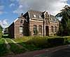 | |
| Vrijstaande woning | circa 1930 | Bronkhorstweg 29 | 51° 45' 42" NB, 5° 42' 55" OL | 0786/GRA72 | Upload foto | |
| Vrijstaande woning | XVIII;XIX | Bronkhorstweg 30 | 51° 45' 37" NB, 5° 43' 13" OL | 0786/GRA73 | Upload foto | |
| Heilig Hartbeeld | 1927 | Custers, J. | Bronkhorstweg ong. | 51° 45' 42" NB, 5° 42' 56" OL | 0786/GRA74 | 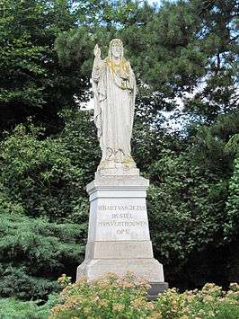 |
| Melkveebedrijf met woning: Krukhuisboerderij | XVIII;XIX | Grippensteinschestraat 2 | 51° 45' 21" NB, 5° 43' 8" OL | 0786/GRA109 | Upload foto | |
| Vrijstaande woonboerderij | Grippensteinschestraat 4 | 51° 45' 13" NB, 5° 43' 3" OL | 0786/GRA110 | Upload foto | ||
| Akkerbouwbedrijf met woning: Langgevelboerderij Huize Houtkamp | circa 1930 | Oude Maasdijk 2 | 51° 45' 39" NB, 5° 42' 1" OL | 0786/GRA75 | Upload foto | |
| Vrijstaande woonboerderij | Pannestaartweg 2 | 51° 45' 38" NB, 5° 42' 50" OL | 0786/GRA76 | Upload foto | ||
| Vrijstaande woning | circa 1920 | Pastoriestraat 17 | 51° 45' 32" NB, 5° 42' 55" OL | 0786/GRA77 | Upload foto | |
| Wegkruis | circa 1930 | Pastoriestraat ong. | 51° 45' 23" NB, 5° 43' 10" OL | 0786/GRA78 | Upload foto | |
| Vrijstaande Langgevelboerderij | XIX d | Tolschestraat 47 | 51° 45' 4" NB, 5° 42' 56" OL | 0786/GRA79 | Upload foto | |
| Kortgevelboerderij | circa 1910 | Voskeschestraat 5-7 | 51° 44' 19" NB, 5° 43' 10" OL | 0786/GRA111 | Upload foto | |
| Veehouderij runderen + woning | Wolfgatschestraat 1 | 51° 45' 26" NB, 5° 42' 50" OL | 0786/GRA112 | Upload foto | ||
| Vrijstaande T-boerderij | circa 1915 | Wolfgatschestraat 8 | 51° 45' 24" NB, 5° 42' 53" OL | 0786/GRA80 | Upload foto |
| Zie de categorie Gemeentelijke monumenten in Grave, Netherlands van Wikimedia Commons voor mediabestanden over dit onderwerp. |
Bronnen, noten en/of referenties
|
This article is issued from
Wikipedia.
The text is licensed under Creative
Commons - Attribution - Sharealike.
Additional terms may apply for the media files.