Lewes (district)
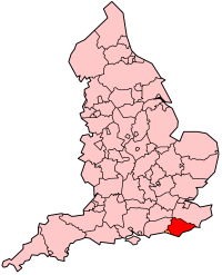
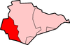
Lewes is een Engels district in het shire-graafschap (non-metropolitan county OF county) East Sussex en telt 103.000 inwoners. De oppervlakte bedraagt 292 km². Hoofdplaats is Lewes.
| Niet-metropolitaans district in Engeland | |||
  | |||
| Situering | |||
| Land | Engeland | ||
| County | East Sussex | ||
| Regio | South East England | ||
| Coördinaten | 50°52'26"NB, 0°0'32"OL | ||
| Algemeen | |||
| Oppervlakte | 292,0642[1] km² | ||
| Inwoners (2018[2]) | 102744 (352 inw./km²) | ||
| ONS-code | E07000063 | ||
| |||
Van de bevolking is 22,6% ouder dan 65 jaar. De werkloosheid bedraagt 2,3% van de beroepsbevolking (cijfers volkstelling 2001).
Civil parishes in district Lewes
Barcombe, Beddingham, Chailey, Ditchling, East Chiltington, Falmer, Firle, Glynde, Hamsey, Iford, Kingston near Lewes, Lewes, Newhaven, Newick, Peacehaven, Piddinghoe, Plumpton, Ringmer, Rodmell, Seaford, South Heighton, Southease, St. Ann (Without), St. John (Without), Streat, Tarring Neville, Telscombe, Westmeston, Wivelsfield.
Bronnen, noten en/of referenties
|
This article is issued from
Wikipedia.
The text is licensed under Creative
Commons - Attribution - Sharealike.
Additional terms may apply for the media files.