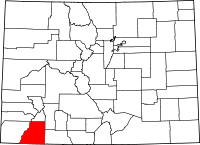
La Plata County
La Plata County is een county in de Amerikaanse staat Colorado.
| County in de Verenigde Staten | |||
 | |||
| Situering | |||
| Staat | Colorado | ||
| Coördinaten | 37°17'24"NB, 107°51'0"WL | ||
| Algemeen | |||
| Oppervlakte | 4.403 km² | ||
| - land | 4.383 km² | ||
| - water | 20 km² | ||
| Inwoners (2000) | 43.941 (10 inw./km²) | ||
| Overig | |||
| Zetel | Durango | ||
| FIPS-code | 08067 | ||
| Opgericht | 1874 | ||
| Foto's | |||
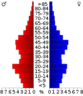 Bevolkingspiramide La Plata County | |||
| Statistieken volkstelling La Plata County | |||
| |||
De county heeft een landoppervlakte van 4.383 km² en telt 43.941 inwoners (volkstelling 2000). De hoofdplaats is Durango.
Bevolkingsontwikkeling
| Historische inwonertallen | |||
|---|---|---|---|
| Jaar | Inwoners | % ± | |
| 1900 | 7.016 | ||
| 1910 | 10.812 | 54,1% | |
| 1920 | 11.218 | 3,8% | |
| 1930 | 12.975 | 15,7% | |
| 1940 | 15.494 | 19,4% | |
| 1950 | 14.880 | −4,0% | |
| 1960 | 19.225 | 29,2% | |
| 1970 | 19.199 | −0,1% | |
| 1980 | 27.424 | 42,8% | |
| 1990 | 32.284 | 17,7% | |
| 2000 | 43.941 | 36,1% | |
| Bron: (en) Historical Decennial Census Population | |||
This article is issued from
Wikipedia.
The text is licensed under Creative
Commons - Attribution - Sharealike.
Additional terms may apply for the media files.