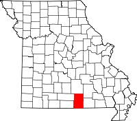
Howell County
Howell County is een county in de Amerikaanse staat Missouri.
| County in de Verenigde Staten | |||
 | |||
| Situering | |||
| Staat | Missouri | ||
| Coördinaten | 36°46'12"NB, 91°53'24"WL | ||
| Algemeen | |||
| Oppervlakte | 2.405 km² | ||
| - land | 2.403 km² | ||
| - water | 2 km² | ||
| Inwoners (2000) | 37.238 (15 inw./km²) | ||
| Overig | |||
| Zetel | West Plains | ||
| FIPS-code | 29091 | ||
| Opgericht | 1857 | ||
| Foto's | |||
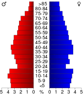 Bevolkingspiramide Howell County | |||
| Statistieken volkstelling Howell County | |||
| |||
De county heeft een landoppervlakte van 2.403 km² en telt 37.238 inwoners (volkstelling 2000). De hoofdplaats is West Plains.
Bevolkingsontwikkeling
| Historische inwonertallen | |||
|---|---|---|---|
| Jaar | Inwoners | % ± | |
| 1900 | 21.834 | ||
| 1910 | 21.065 | −3,5% | |
| 1920 | 21.102 | 0,2% | |
| 1930 | 19.672 | −6,8% | |
| 1940 | 22.270 | 13,2% | |
| 1950 | 22.725 | 2,0% | |
| 1960 | 22.027 | −3,1% | |
| 1970 | 23.521 | 6,8% | |
| 1980 | 28.807 | 22,5% | |
| 1990 | 31.447 | 9,2% | |
| 2000 | 37.238 | 18,4% | |
| Bron: (en) Historical Decennial Census Population | |||
This article is issued from
Wikipedia.
The text is licensed under Creative
Commons - Attribution - Sharealike.
Additional terms may apply for the media files.