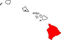
Hawaii County
Hawaii County is een county in de Amerikaanse staat Hawaï, tevens de grootste. De county seat is in Hilo.
| County in de Verenigde Staten | |||
 | |||
| Situering | |||
| Staat | Hawaï | ||
| Coördinaten | 19°35'NB, 155°30'WL | ||
| Algemeen | |||
| Oppervlakte | 13.175 km² | ||
| - land | 10.433 km² | ||
| - water | 2.742 km² | ||
| Inwoners (2010) | 185.079 (18 inw./km²) | ||
| Overig | |||
| FIPS-code | 15001 | ||
| Foto's | |||
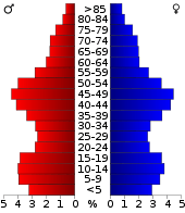 Bevolkingspiramide Hawaii County | |||
| Statistieken volkstelling Hawaii County | |||
| |||
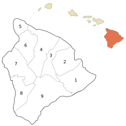
De districten van Hawaii County: Puna (1), South Hilo (2), North Hilo (3), Hāmākua (4), North Kohala (5), South Kohala (6), North Kona (7), South Kona (8), Kaʻū (9).
De county heeft een landoppervlakte van 10.433 km² en telt 185.079 inwoners (volkstelling 2010).
Bevolkingsontwikkeling
| Historische inwonertallen | |||
|---|---|---|---|
| Jaar | Inwoners | % ± | |
| 1900 | 46.843 | ||
| 1910 | 55.382 | 18,2% | |
| 1920 | 64.895 | 17,2% | |
| 1930 | 73.325 | 13,0% | |
| 1940 | 73.276 | −0,1% | |
| 1950 | 68.350 | −6,7% | |
| 1960 | 61.332 | −10,3% | |
| 1970 | 63.468 | 3,5% | |
| 1980 | 92.053 | 45,0% | |
| 1990 | 120.317 | 30,7% | |
| 2000 | 148.677 | 23,6% | |
| 2010 | 185.079 | 24,5% | |
| Bron: (en) Historical Decennial Census Population | |||
Externe link
| Zie de categorie Hawaii County, Hawaii van Wikimedia Commons voor mediabestanden over dit onderwerp. |
This article is issued from
Wikipedia.
The text is licensed under Creative
Commons - Attribution - Sharealike.
Additional terms may apply for the media files.