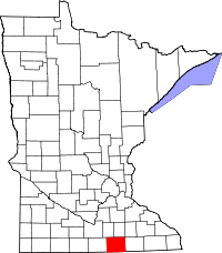
Freeborn County
Freeborn County is een county in de Amerikaanse staat Minnesota.
| County in de Verenigde Staten | |||
 | |||
| Situering | |||
| Staat | Minnesota | ||
| Coördinaten | 43°40'12"NB, 93°21'0"WL | ||
| Algemeen | |||
| Oppervlakte | 1.872 km² | ||
| - land | 1.833 km² | ||
| - water | 39 km² | ||
| Inwoners (2000) | 32.584 (18 inw./km²) | ||
| Overig | |||
| Zetel | Albert Lea | ||
| FIPS-code | 27047 | ||
| Opgericht | 1855 | ||
| Foto's | |||
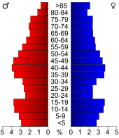 Bevolkingspiramide Freeborn County | |||
| Statistieken volkstelling Freeborn County | |||
| |||
De county heeft een landoppervlakte van 1.833 km² en telt 32.584 inwoners (volkstelling 2000). De hoofdplaats is Albert Lea.
Bevolkingsontwikkeling
| Historische inwonertallen | |||
|---|---|---|---|
| Jaar | Inwoners | % ± | |
| 1900 | 21.838 | ||
| 1910 | 22.282 | 2,0% | |
| 1920 | 24.692 | 10,8% | |
| 1930 | 28.741 | 16,4% | |
| 1940 | 31.780 | 10,6% | |
| 1950 | 34.517 | 8,6% | |
| 1960 | 37.891 | 9,8% | |
| 1970 | 38.064 | 0,5% | |
| 1980 | 36.329 | −4,6% | |
| 1990 | 33.060 | −9,0% | |
| 2000 | 32.584 | −1,4% | |
| Bron: (en) Historical Decennial Census Population | |||
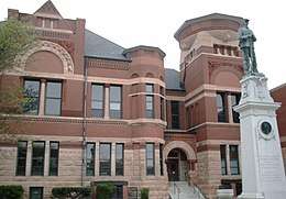
Freeborn County Courthouse
This article is issued from
Wikipedia.
The text is licensed under Creative
Commons - Attribution - Sharealike.
Additional terms may apply for the media files.