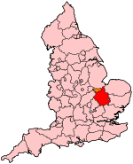
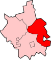
East Cambridgeshire
East Cambridgeshire is een Engels district in het shire-graafschap (non-metropolitan county OF county) Cambridgeshire en telt 89.000 inwoners. De oppervlakte bedraagt 651 km².
| Niet-metropolitaans district in Engeland | |||
  | |||
| Situering | |||
| Land | Engeland | ||
| County | Cambridgeshire | ||
| Regio | East of England | ||
| Coördinaten | 52°23'13"NB, 0°17'38"OL | ||
| Algemeen | |||
| Oppervlakte | 651,2792[1] km² | ||
| Inwoners (2018[2]) | 89362 (137 inw./km²) | ||
| ONS-code | E07000009 | ||
| |||
Van de bevolking is 16,4% ouder dan 65 jaar. De werkloosheid bedraagt 2,2% van de beroepsbevolking (cijfers volkstelling 2001).
Civil parishes in district East Cambridgeshire
Ashley, Bottisham, Brinkley, Burrough Green, Burwell, Cheveley, Chippenham, Coveney, Downham, Dullingham, Ely, Fordham, Haddenham, Isleham, Kennett, Kirtling, Littleport, Lode, Mepal, Reach, Snailwell, Soham, Stetchworth, Stretham, Sutton, Swaffham Bulbeck, Swaffham Prior, Thetford, Wentworth, Westley Waterless, Wicken, Wilburton, Witcham, Witchford, Woodditton.
Bronnen, noten en/of referenties
|
This article is issued from
Wikipedia.
The text is licensed under Creative
Commons - Attribution - Sharealike.
Additional terms may apply for the media files.