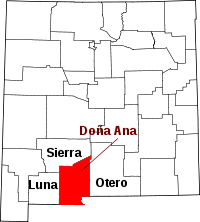
Doña Ana County
Dona Ana County is een county in de Amerikaanse staat New Mexico.
| County in de Verenigde Staten | |||
 | |||
| Situering | |||
| Staat | New Mexico | ||
| Coördinaten | 32°18'43,99"NB, 106°46'41,99"WL | ||
| Algemeen | |||
| Oppervlakte | 9.880 km² | ||
| - land | 9.861 km² | ||
| - water | 19 km² | ||
| Inwoners (2000) | 174.682 (18 inw./km²) | ||
| Overig | |||
| FIPS-code | 35013 | ||
| Foto's | |||
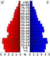 Bevolkingspiramide Dona Ana County | |||
| Statistieken volkstelling Dona Ana County | |||
| |||
De county heeft een landoppervlakte van 9.861 km² en telt 174.682 inwoners (volkstelling 2000).
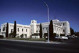
Doña Ana County Courthouse
| County's in New Mexico |
|---|
|
Bernalillo · Catron · Chaves · Cibola · Colfax · Curry · De Baca · Doña Ana · Eddy · Grant · Guadalupe · Harding · Hidalgo · Lea · Lincoln · Los Alamos · Luna · McKinley · Mora · Otero · Quay · Rio Arriba · Roosevelt · San Juan · San Miguel · Sandoval · Santa Fe · Sierra · Socorro · Taos · Torrance · Union · Valencia |
This article is issued from
Wikipedia.
The text is licensed under Creative
Commons - Attribution - Sharealike.
Additional terms may apply for the media files.