Dawson County (Georgia)
Dawson County is een county in de Amerikaanse staat Georgia.
| County in de Verenigde Staten | |||
 | |||
| Situering | |||
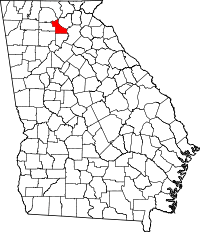
| Staat | Georgia | ||
| Coördinaten | 34°26'24"NB, 84°10'12"WL | ||
| Algemeen | |||
| Oppervlakte | 555 km² | ||
| - land | 547 km² | ||
| - water | 8 km² | ||
| Inwoners (2000) | 15.999 (29 inw./km²) | ||
| Overig | |||
| Zetel | Dawsonville | ||
| FIPS-code | 13085 | ||
| Opgericht | 1857 | ||
| Foto's | |||
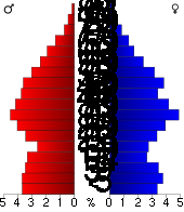 Bevolkingspiramide Dawson County | |||
| Statistieken volkstelling Dawson County | |||
| |||
De county heeft een landoppervlakte van 547 km² en telt 15.999 inwoners (volkstelling 2000). De hoofdplaats is Dawsonville.
Bevolkingsontwikkeling
| Historische inwonertallen | |||
|---|---|---|---|
| Jaar | Inwoners | % ± | |
| 1900 | 5.442 | ||
| 1910 | 4.686 | −13,9% | |
| 1920 | 4.204 | −10,3% | |
| 1930 | 3.502 | −16,7% | |
| 1940 | 4.479 | 27,9% | |
| 1950 | 3.712 | −17,1% | |
| 1960 | 3.590 | −3,3% | |
| 1970 | 3.639 | 1,4% | |
| 1980 | 4.774 | 31,2% | |
| 1990 | 9.429 | 97,5% | |
| 2000 | 15.999 | 69,7% | |
| Bron: (en) Historical Decennial Census Population | |||
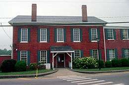
Dawson County Courthouse
| Zie de categorie Dawson County, Georgia van Wikimedia Commons voor mediabestanden over dit onderwerp. |
This article is issued from
Wikipedia.
The text is licensed under Creative
Commons - Attribution - Sharealike.
Additional terms may apply for the media files.