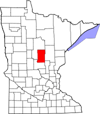
Crow Wing County
Crow Wing County is een county in de Amerikaanse staat Minnesota.
| County in de Verenigde Staten | |||
 | |||
| Situering | |||
| Staat | Minnesota | ||
| Coördinaten | 46°29'24"NB, 94°4'12"WL | ||
| Algemeen | |||
| Oppervlakte | 2.995 km² | ||
| - land | 2.581 km² | ||
| - water | 414 km² | ||
| Inwoners (2000) | 55.099 (21 inw./km²) | ||
| Overig | |||
| Zetel | Brainerd | ||
| FIPS-code | 27035 | ||
| Opgericht | 1857 | ||
| Foto's | |||
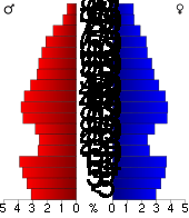 Bevolkingspiramide Crow Wing County | |||
| Statistieken volkstelling Crow Wing County | |||
| |||
De county heeft een landoppervlakte van 2.581 km² en telt 55.099 inwoners (volkstelling 2000). De hoofdplaats is Brainerd.
Bevolkingsontwikkeling
| Historische inwonertallen | |||
|---|---|---|---|
| Jaar | Inwoners | % ± | |
| 1900 | 14.250 | ||
| 1910 | 16.861 | 18,3% | |
| 1920 | 24.566 | 45,7% | |
| 1930 | 25.627 | 4,3% | |
| 1940 | 30.226 | 17,9% | |
| 1950 | 30.875 | 2,1% | |
| 1960 | 32.134 | 4,1% | |
| 1970 | 34.826 | 8,4% | |
| 1980 | 41.722 | 19,8% | |
| 1990 | 44.249 | 6,1% | |
| 2000 | 55.099 | 24,5% | |
| Bron: (en) Historical Decennial Census Population | |||
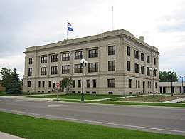
Crow Wing County Courthouse
This article is issued from
Wikipedia.
The text is licensed under Creative
Commons - Attribution - Sharealike.
Additional terms may apply for the media files.