Copeland (Engeland)
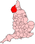
Copeland is een Engels district in het shire-graafschap (non-metropolitan county OF county) Cumbria en telt 69.318 inwoners. De oppervlakte bedraagt 732 km².
| Niet-metropolitaans district in Engeland | |||
  | |||
| Situering | |||
| Land | Engeland | ||
| County | Cumbria | ||
| Regio | North West England | ||
| Coördinaten | 54°25'52"NB, 3°23'20"WL | ||
| Algemeen | |||
| Oppervlakte | 731,7419[1] km² | ||
| Inwoners (2018[2]) | 68424 (94 inw./km²) | ||
| ONS-code | E07000029 | ||
| |||
Van de bevolking is 16,4% ouder dan 65 jaar. De werkloosheid bedraagt 5,0% van de beroepsbevolking (cijfers volkstelling 2001).
Civil parishes in district Copeland
Arlecdon and Frizington, Beckermet, Bootle, Cleator Moor, Distington, Drigg and Carleton, Egremont, Ennerdale and Kinniside, Eskdale, Gosforth, Haile, Irton with Santon, Lamplugh, Lowca, Lowside Quarter, Millom, Millom Without, Moresby, Muncaster, Parton, Ponsonby, Seascale, St. Bees, Ulpha, Waberthwaite, Wasdale, Weddicar, Whicham.
Bronnen, noten en/of referenties
|
This article is issued from
Wikipedia.
The text is licensed under Creative
Commons - Attribution - Sharealike.
Additional terms may apply for the media files.