Colchester (district)
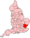
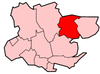
Colchester is een Engels district in het shire-graafschap (non-metropolitan county OF county) Essex en telt 193.000 inwoners. De oppervlakte bedraagt 329 km². Hoofdplaats is Colchester.
| Niet-metropolitaans district in Engeland | |||
  | |||
| Situering | |||
| Land | Engeland | ||
| County | Essex | ||
| Regio | East of England | ||
| Coördinaten | 51°53'19"NB, 0°54'13"OL | ||
| Algemeen | |||
| Oppervlakte | 329,0838[1] km² | ||
| Inwoners (2018[2]) | 192523 (585 inw./km²) | ||
| ONS-code | E07000071 | ||
| |||
Van de bevolking is 14,7% ouder dan 65 jaar. De werkloosheid bedraagt 2,3% van de beroepsbevolking (cijfers volkstelling 2001).
Plaatsen in district Colchester
Civil parishes in district Colchester
Abberton, Aldham, Birch, Boxted, Chappel, Copford, Dedham, East Donyland, East Mersea, Eight Ash Green, Fingringhoe, Fordham, Great Horkesley, Great Tey, Great and Little Wigborough, Langenhoe, Langham, Layer Breton, Layer Marney, Layer-de-la-Haye, Little Horkesley, Marks Tey, Messing-cum-Inworth, Mount Bures, Myland, Peldon, Salcott, Stanway, Tiptree, Virley, Wakes Colne, West Bergholt, West Mersea, Wivenhoe, Wormingford.
Bronnen, noten en/of referenties
|
This article is issued from
Wikipedia.
The text is licensed under Creative
Commons - Attribution - Sharealike.
Additional terms may apply for the media files.