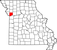
Clay County (Missouri)
Clay County is een county in de Amerikaanse staat Missouri.
| County in de Verenigde Staten | |||
 | |||
| Situering | |||
| Staat | Missouri | ||
| Coördinaten | 39°18'36"NB, 94°25'12"WL | ||
| Algemeen | |||
| Oppervlakte | 1.059 km² | ||
| - land | 1.027 km² | ||
| - water | 32 km² | ||
| Inwoners (2000) | 184.006 (179 inw./km²) | ||
| Overig | |||
| Zetel | Liberty | ||
| FIPS-code | 29047 | ||
| Opgericht | 1822 | ||
| Foto's | |||
 Bevolkingspiramide Clay County | |||
| Statistieken volkstelling Clay County | |||
| |||
De county heeft een landoppervlakte van 1.027 km² en telt 184.006 inwoners (volkstelling 2000). De hoofdplaats is Liberty.
Geboren
- Noah Beery (1882-1946), acteur
Bevolkingsontwikkeling
| Historische inwonertallen | |||
|---|---|---|---|
| Jaar | Inwoners | % ± | |
| 1900 | 18.903 | ||
| 1910 | 20.302 | 7,4% | |
| 1920 | 20.455 | 0,8% | |
| 1930 | 26.811 | 31,1% | |
| 1940 | 30.417 | 13,4% | |
| 1950 | 45.221 | 48,7% | |
| 1960 | 87.474 | 93,4% | |
| 1970 | 123.322 | 41,0% | |
| 1980 | 136.488 | 10,7% | |
| 1990 | 153.411 | 12,4% | |
| 2000 | 184.006 | 19,9% | |
| Bron: (en) Historical Decennial Census Population | |||
This article is issued from
Wikipedia.
The text is licensed under Creative
Commons - Attribution - Sharealike.
Additional terms may apply for the media files.