Clay County (Mississippi)
Clay County is een county in de Amerikaanse staat Mississippi.
| County in de Verenigde Staten | |||
 | |||
| Situering | |||
| Staat | Mississippi | ||
| Coördinaten | 33°39'0"NB, 88°46'12"WL | ||
| Algemeen | |||
| Oppervlakte | 1.077 km² | ||
| - land | 1.058 km² | ||
| - water | 19 km² | ||
| Inwoners (2000) | 21.979 (21 inw./km²) | ||
| Overig | |||
| Zetel | West Point | ||
| FIPS-code | 28025 | ||
| Opgericht | 1871 | ||
| Foto's | |||
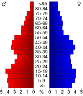 Bevolkingspiramide Clay County | |||
| Statistieken volkstelling Clay County | |||
| |||
De county heeft een landoppervlakte van 1.058 km² en telt 21.979 inwoners (volkstelling 2000). De hoofdplaats is West Point.
Bevolkingsontwikkeling
| Historische inwonertallen | |||
|---|---|---|---|
| Jaar | Inwoners | % ± | |
| 1900 | 19.563 | ||
| 1910 | 20.203 | 3,3% | |
| 1920 | 17.490 | −13,4% | |
| 1930 | 17.931 | 2,5% | |
| 1940 | 19.030 | 6,1% | |
| 1950 | 17.757 | −6,7% | |
| 1960 | 18.933 | 6,6% | |
| 1970 | 18.840 | −0,5% | |
| 1980 | 21.082 | 11,9% | |
| 1990 | 21.120 | 0,2% | |
| 2000 | 21.979 | 4,1% | |
| Bron: (en) Historical Decennial Census Population | |||
This article is issued from
Wikipedia.
The text is licensed under Creative
Commons - Attribution - Sharealike.
Additional terms may apply for the media files.