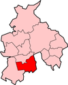
Chorley (district)
Chorley is een Engels district in het shire-graafschap (non-metropolitan county OF county) Lancashire en telt 117.000 inwoners. De oppervlakte bedraagt 203 km². Hoofdplaats is Chorley.
| Niet-metropolitaans district in Engeland | |||
  | |||
| Situering | |||
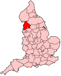
| Land | Engeland | ||
| County | Lancashire | ||
| Regio | North West England | ||
| Coördinaten | 53°39'11"NB, 2°37'55"WL | ||
| Algemeen | |||
| Oppervlakte | 202,7961[1] km² | ||
| Inwoners (2018[2]) | 116821 (576 inw./km²) | ||
| ONS-code | E07000118 | ||
| |||
Van de bevolking is 14,2% ouder dan 65 jaar. De werkloosheid bedraagt 2,6% van de beroepsbevolking (cijfers volkstelling 2001).
Plaatsen in district Chorley
Civil parishes in district Chorley
Adlington, Anderton, Anglezarke, Astley Village, Bretherton, Brindle, Charnock Richard, Clayton-le-Woods, Coppull, Croston, Cuerden, Eccleston, Euxton, Heapey, Heath Charnock, Heskin, Hoghton, Mawdesley, Rivington, Ulnes Walton, Wheelton, Whittle-le-Woods, Withnell.
Bronnen, noten en/of referenties
|
This article is issued from
Wikipedia.
The text is licensed under Creative
Commons - Attribution - Sharealike.
Additional terms may apply for the media files.