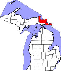
Chippewa County (Michigan)
Chippewa County is een county in de Amerikaanse staat Michigan.
| County in de Verenigde Staten | |||
 | |||
| Situering | |||
| Staat | Michigan | ||
| Coördinaten | 46°19'12"NB, 84°31'12"WL | ||
| Algemeen | |||
| Oppervlakte | 6.988 km² | ||
| - land | 4.043 km² | ||
| - water | 2.945 km² | ||
| Inwoners (2000) | 38.543 (10 inw./km²) | ||
| Overig | |||
| Zetel | Sault Ste. Marie | ||
| FIPS-code | 26033 | ||
| Opgericht | 1827 | ||
| Foto's | |||
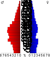 Bevolkingspiramide Chippewa County | |||
| Statistieken volkstelling Chippewa County | |||
| |||
De county heeft een landoppervlakte van 4.043 km² en telt 38.543 inwoners (volkstelling 2000). De hoofdplaats is Sault Ste. Marie.
Bevolkingsontwikkeling
| Historische inwonertallen | |||
|---|---|---|---|
| Jaar | Inwoners | % ± | |
| 1900 | 21.338 | ||
| 1910 | 24.472 | 14,7% | |
| 1920 | 24.818 | 1,4% | |
| 1930 | 25.047 | 0,9% | |
| 1940 | 27.807 | 11,0% | |
| 1950 | 29.206 | 5,0% | |
| 1960 | 32.655 | 11,8% | |
| 1970 | 32.412 | −0,7% | |
| 1980 | 29.029 | −10,4% | |
| 1990 | 34.604 | 19,2% | |
| 2000 | 38.543 | 11,4% | |
| Bron: (en) Historical Decennial Census Population | |||
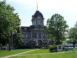
Chippewa County Courthouse
| Zie de categorie Chippewa County, Michigan van Wikimedia Commons voor mediabestanden over dit onderwerp. |
This article is issued from
Wikipedia.
The text is licensed under Creative
Commons - Attribution - Sharealike.
Additional terms may apply for the media files.