Cherwell (district)
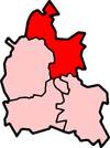
Cherwell is een Engels district in het shire-graafschap (non-metropolitan county OF county) Oxfordshire en telt 149.000 inwoners. De oppervlakte bedraagt 589 km². Hoofdplaats is Banbury.
| Niet-metropolitaans district in Engeland | |||
  | |||
| Situering | |||
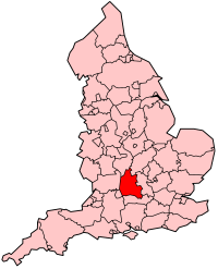
| Land | Engeland | ||
| County | Oxfordshire | ||
| Regio | South East England | ||
| Coördinaten | 51°57'NB, 1°15'WL | ||
| Algemeen | |||
| Oppervlakte | 588,7412[1] km² | ||
| Inwoners (2018[2]) | 149161 (253 inw./km²) | ||
| Hoofdplaats ONS-code | Banbury E07000177 | ||
| |||
Van de bevolking is 13,4% ouder dan 65 jaar. De werkloosheid bedraagt 1,9% van de beroepsbevolking (cijfers volkstelling 2001).
Plaatsen in district Cherwell
Civil parishes in district Cherwell
Adderbury, Ambrosden, Ardley, Arncott, Banbury, Barford St. John and St. Michael, Begbroke, Bicester, Blackthorn, Bletchingdon, Bloxham, Bodicote, Bourton, Broughton, Bucknell, Caversfield, Charlton-on-Otmoor, Chesterton, Claydon with Clattercot, Cottisford, Cropredy, Deddington, Drayton, Duns Tew, Epwell, Fencott and Murcott, Finmere, Fringford, Fritwell, Godington, Gosford and Water Eaton, Hampton Gay and Poyle, Hanwell, Hardwick with Tusmore, Hethe, Hook Norton, Horley, Hornton, Horton-cum-Studley, Islip, Kidlington, Kirtlington, Launton, Lower Heyford, Merton, Middle Aston, Middleton Stoney, Milcombe, Milton, Mixbury, Mollington, Newton Purcell with Shelswell, Noke, North Aston, North Newington, Oddington, Piddington, Prescote, Shenington with Alkerton, Shipton-on-Cherwell and Thrupp, Shutford, Sibford Ferris, Sibford Gower, Somerton, Souldern, South Newington, Steeple Aston, Stoke Lyne, Stratton Audley, Swalcliffe, Tadmarton, Upper Heyford, Wardington, Wendlebury, Weston-on-the-Green, Wigginton, Wroxton, Yarnton.
Bronnen, noten en/of referenties
|