Carter County (Kentucky)
Carter County is een county in de Amerikaanse staat Kentucky.
| County in de Verenigde Staten | |||
 | |||
| Situering | |||
| Staat | Kentucky | ||
| Coördinaten | 38°19'48"NB, 83°3'0"WL | ||
| Algemeen | |||
| Oppervlakte | 1.067 km² | ||
| - land | 1.063 km² | ||
| - water | 4 km² | ||
| Inwoners (2000) | 26.889 (25 inw./km²) | ||
| Overig | |||
| Zetel | Grayson | ||
| FIPS-code | 21043 | ||
| Opgericht | 1838 | ||
| Foto's | |||
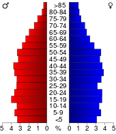 Bevolkingspiramide Carter County | |||
| Statistieken volkstelling Carter County | |||
| |||
De county heeft een landoppervlakte van 1.063 km² en telt 26.889 inwoners (volkstelling 2000). De hoofdplaats is Grayson.
Bevolkingsontwikkeling
| Historische inwonertallen | |||
|---|---|---|---|
| Jaar | Inwoners | % ± | |
| 1900 | 20.228 | ||
| 1910 | 21.966 | 8,6% | |
| 1920 | 22.474 | 2,3% | |
| 1930 | 23.839 | 6,1% | |
| 1940 | 25.545 | 7,2% | |
| 1950 | 22.559 | −11,7% | |
| 1960 | 20.817 | −7,7% | |
| 1970 | 19.850 | −4,6% | |
| 1980 | 25.060 | 26,2% | |
| 1990 | 24.340 | −2,9% | |
| 2000 | 26.889 | 10,5% | |
| Bron: (en) Historical Decennial Census Population | |||

Carter County Courthouse
This article is issued from
Wikipedia.
The text is licensed under Creative
Commons - Attribution - Sharealike.
Additional terms may apply for the media files.