Broxbourne (district)
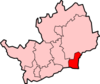
Broxbourne is een Engels district in het shire-graafschap (non-metropolitan county OF county) Hertfordshire en telt 97.000 inwoners. De oppervlakte bedraagt 51 km². Hoofdplaats is Broxbourne.
| Niet-metropolitaans district in Engeland | |||
  | |||
| Situering | |||
| Land | Engeland | ||
| County | Hertfordshire | ||
| Regio | East of England | ||
| Coördinaten | 51°43'NB, 0°3'WL | ||
| Algemeen | |||
| Oppervlakte | 51,4422[1] km² | ||
| Inwoners (2018[2]) | 96876 (1883 inw./km²) | ||
| ONS-code | E07000095 | ||
| |||
Van de bevolking is 14,7% ouder dan 65 jaar. De werkloosheid bedraagt 2,3% van de beroepsbevolking (cijfers volkstelling 2001).
Plaatsen in district Broxbourne
Bronnen, noten en/of referenties
|
This article is issued from
Wikipedia.
The text is licensed under Creative
Commons - Attribution - Sharealike.
Additional terms may apply for the media files.