Braintree (district)
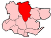
Braintree is een Engels district in het shire-graafschap (non-metropolitan county OF county) Essex en telt 152.000 inwoners. De oppervlakte bedraagt 612 km². Hoofdplaats is Braintree.
| Niet-metropolitaans district in Engeland | |||
  | |||
| Situering | |||
| Land | Engeland | ||
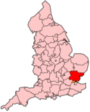
| County | Essex | ||
| Regio | East of England | ||
| Coördinaten | 51°52'55"NB, 0°33'9"OL | ||
| Algemeen | |||
| Oppervlakte | 611,7081[1] km² | ||
| Inwoners (2018[2]) | 151561 (248 inw./km²) | ||
| ONS-code | E07000067 | ||
| |||
Van de bevolking is 14,9% ouder dan 65 jaar. De werkloosheid bedraagt 2,3% van de beroepsbevolking (cijfers volkstelling 2001).
Civil parishes in district Braintree
Alphamstone, Ashen, Bardfield Saling, Belchamp Otten, Belchamp St. Paul, Belchamp Walter, Birdbrook, Black Notley, Borley, Bradwell, Bulmer, Bures Hamlet, Castle Hedingham, Coggeshall, Colne Engaine, Cressing, Earls Colne, Fairstead, Faulkbourne, Feering, Finchingfield, Foxearth, Gestingthorpe, Gosfield, Great Bardfield, Great Henny, Great Maplestead, Great Notley, Great Saling, Great Yeldham, Greenstead Green and Halstead Rural, Halstead, Hatfield Peverel, Helions Bumpstead, Kelvedon, Lamarsh, Liston, Little Henny, Little Maplestead, Little Yeldham, Middleton, Ovington, Panfield, Pebmarsh, Pentlow, Rayne, Ridgewell, Rivenhall, Shalford, Sible Hedingham, Silver End, Stambourne, Steeple Bumpstead, Stisted, Sturmer, Terling, Tilbury Juxta Clare, Toppesfield, Twinstead, Wethersfield, White Colne, White Notley, Wickham St. Paul, Witham.
Bronnen, noten en/of referenties
|