Bedford (district)
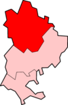
Bedford is een Engels district in het graafschap Bedfordshire en telt 172.000 inwoners. De oppervlakte bedraagt 476 km². Hoofdplaats is de stad Bedford.
| Unitaire autoriteit in Engeland | |||
  | |||
| Situering | |||
| Land | Engeland | ||
| County | Bedfordshire | ||
| Regio | East of England | ||
| Coördinaten | 52°8'4"NB, 0°27'47"WL | ||
| Algemeen | |||
| Oppervlakte | 476,4082[1] km² | ||
| Inwoners (2018[2]) | 171623 (360 inw./km²) | ||
| Hoofdplaats ONS-code | Bedford E06000055 | ||
| |||
Van de bevolking is 14,9% ouder dan 65 jaar. De werkloosheid bedraagt 3,1% van de beroepsbevolking (cijfers volkstelling 2001).
Civil parishes in district Bedford
Biddenham, Bletsoe, Bolnhurst and Keysoe, Brickhill, Bromham, Cardington, Carlton and Chellington, Clapham, Colmworth, Cople, Dean and Shelton, Eastcotts, Elstow, Felmersham, Great Barford, Great Denham, Harrold, Kempston, Kempston Rural, Knotting and Souldrop, Little Barford, Little Staughton, Melchbourne and Yielden, Milton Ernest, Oakley, Odell, Pavenham, Pertenhall, Podington, Ravensden, Renhold, Riseley, Roxton, Sharnbrook, Stagsden, Staploe, Stevington, Stewartby, Sharnbrook, Stagsden, Staploe, Stevington, Stewartby, Swineshead, Thurleigh, Turvey, Wilden, Willington, Wilshamstead, Wootton, Wyboston, Chawston and Colesden, Wymington.
Plaatsen in district Bedford
Bronnen, noten en/of referenties
|