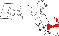
Barnstable County
Barnstable County is een county in de Amerikaanse staat Massachusetts. Het oppervlak van Barnstable County komt overeen met Cape Cod. Een andere plaats is Yarmouth.
| County in de Verenigde Staten | |||
 | |||
| Situering | |||
| Staat | Massachusetts | ||
| Coördinaten | 41°41'56,389"NB, 70°18'6,520"WL | ||
| Algemeen | |||
| Oppervlakte | 3.381 km² | ||
| - land | 1.024 km² | ||
| - water | 2.357 km² | ||
| Inwoners (2000) | 222.230 (217 inw./km²) | ||
| Overig | |||
| Zetel | Barnstable | ||
| FIPS-code | 25001 | ||
| Opgericht | 1685 | ||
| Detailkaart | |||
 | |||
| Historische kaart van Barnstable County | |||
| Foto's | |||
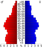 Bevolkingspiramide Barnstable County | |||
| Statistieken volkstelling Barnstable County | |||
| |||
De county heeft een landoppervlakte van 1.024 km² en telt 222.230 inwoners (volkstelling 2000). De hoofdplaats is Barnstable. Een andere plaats is Yarmouth.
Bevolkingsontwikkeling
| Historische inwonertallen | |||
|---|---|---|---|
| Jaar | Inwoners | % ± | |
| 1900 | 27.826 | ||
| 1910 | 27.542 | −1,0% | |
| 1920 | 26.670 | −3,2% | |
| 1930 | 32.305 | 21,1% | |
| 1940 | 37.295 | 15,4% | |
| 1950 | 46.805 | 25,5% | |
| 1960 | 70.286 | 50,2% | |
| 1970 | 96.656 | 37,5% | |
| 1980 | 147.925 | 53,0% | |
| 1990 | 186.605 | 26,1% | |
| 2000 | 222.230 | 19,1% | |
| Bron: (en) Historical Decennial Census Population | |||

Barnstable County Courthouse
This article is issued from
Wikipedia.
The text is licensed under Creative
Commons - Attribution - Sharealike.
Additional terms may apply for the media files.