Barnsley (district)
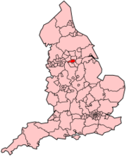
Metropolitan Borough of Barnsley is een local authority district (gemeente) van het type stedelijk district, gelegen in het stedelijk graafschap (metropolitan county) South Yorkshire in de regio Yorkshire and the Humber in Engeland en telt 245.000 inwoners. De oppervlakte bedraagt 329 km².
| Metropolitaans district in Engeland | |||
 | |||
| Situering | |||
| Land | Engeland | ||
| County | South Yorkshire | ||
| Regio | Yorkshire and the Humber | ||
| Coördinaten | 53°33'NB, 1°28'WL | ||
| Algemeen | |||
| Oppervlakte | 329,0776[1] km² | ||
| Inwoners (2018[2]) | 245199 (745 inw./km²) | ||
| ONS-code | E08000016 | ||
| |||
Van de bevolking is 16,2% ouder dan 65 jaar. De werkloosheid bedraagt 3,9% van de beroepsbevolking (cijfers volkstelling 2001).
Plaatsen in district Barnsley
Ardsley, Athersley, Barnsley, Barugh, Barugh-Green, Birdwell, Bolton upon Dearne, Carlecotes, Carlton, Cubley, Cudworth, Darfield, Darton, Dodworth, Elsecar, Gawber, Gilroyd, Goldthorpe, Grimethorpe, Haigh, Higham, Honeywell, Hood Green, Hoyland, Hoylandswaine, Hoyland Common, Ingbirchworth, Jump, Kendray, Kexbrough, Kingstone, Lundwood, Mapplewell, Millhouses, Millhouse Green, Monk Bretton, New Lodge, Platts Common, Pilley, Pogmoor, Redbrook, Royston, Silkstone Common, Smithies, Staincross, Stairfoot, Thurlstone, Thurnscoe, Ward Green, Wilthorpe, Woolley Colliery, Wombwell, Worsbrough.
Civil parishes in district Barnsley
Billingley, Brierley, Cawthorne, Dunford, Great Houghton, Gunthwaite and Ingbirchworth, High Hoyland, Hunshelf, Langsett, Little Houghton, Oxspring, Penistone, Shafton, Silkstone, Stainborough, Tankersley, Thurgoland, Wortley.
Bronnen, noten en/of referenties
|