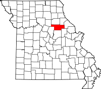
Audrain County
Audrain County is een county in de Amerikaanse staat Missouri.
| County in de Verenigde Staten | |||
 | |||
| Situering | |||
| Staat | Missouri | ||
| Coördinaten | 39°12'36"NB, 91°50'24"WL | ||
| Algemeen | |||
| Oppervlakte | 1.805 km² | ||
| - land | 1.795 km² | ||
| - water | 10 km² | ||
| Inwoners (2000) | 25.853 (14 inw./km²) | ||
| Overig | |||
| Zetel | Mexico | ||
| FIPS-code | 29007 | ||
| Opgericht | 1831 | ||
| Foto's | |||
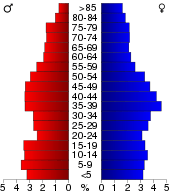 Bevolkingspiramide Audrain County | |||
| Statistieken volkstelling Audrain County | |||
| |||
De county heeft een landoppervlakte van 1.795 km² en telt 25.853 inwoners (volkstelling 2000). De hoofdplaats is Mexico.
Bevolkingsontwikkeling
| Historische inwonertallen | |||
|---|---|---|---|
| Jaar | Inwoners | % ± | |
| 1900 | 21.160 | ||
| 1910 | 21.687 | 2,5% | |
| 1920 | 20.589 | −5,1% | |
| 1930 | 22.077 | 7,2% | |
| 1940 | 22.673 | 2,7% | |
| 1950 | 23.829 | 5,1% | |
| 1960 | 26.079 | 9,4% | |
| 1970 | 25.362 | −2,7% | |
| 1980 | 26.458 | 4,3% | |
| 1990 | 23.599 | −10,8% | |
| 2000 | 25.853 | 9,6% | |
| Bron: (en) Historical Decennial Census Population | |||
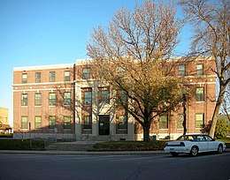
Audrain County Courthouse
| Zie de categorie Audrain County, Missouri van Wikimedia Commons voor mediabestanden over dit onderwerp. |
This article is issued from
Wikipedia.
The text is licensed under Creative
Commons - Attribution - Sharealike.
Additional terms may apply for the media files.