Ashford (district)
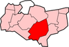
Ashford is een Engels district in het shire-graafschap (non-metropolitan county OF county) Kent en telt 129.000 inwoners. De oppervlakte bedraagt 581 km².
| Niet-metropolitaans district in Engeland | |||
  | |||
| Situering | |||
| Land | Engeland | ||
| County | Kent | ||
| Regio | South East England | ||
| Coördinaten | 51°8'47"NB, 0°52'3"OL | ||
| Algemeen | |||
| Oppervlakte | 580,6174[1] km² | ||
| Inwoners (2018[2]) | 129281 (223 inw./km²) | ||
| Hoofdplaats ONS-code | Ashford E07000105 | ||
| |||
Van de bevolking is 16,2% ouder dan 65 jaar. De werkloosheid bedraagt 2,4% van de beroepsbevolking (cijfers volkstelling 2001).
Civil parishes in district Ashford
Aldington, Appledore, Bethersden, Biddenden, Bilsington, Bonnington, Boughton Aluph, Brabourne, Brook, Challock, Charing, Chilham, Crundale, Eastwell, Egerton, Godmersham, Great Chart with Singleton, Hastingleigh, High Halden, Hothfield, Kenardington, Kingsnorth, Little Chart, Mersham, Molash, Newenden, Orlestone, Pluckley, Rolvenden, Ruckinge, Sevington, Shadoxhurst, Smarden, Smeeth, Stanhope, Stone-cum-Ebony, Tenterden, Warehorne, Westwell, Wittersham, Woodchurch, Wye with Hinxhill.
Zie ook
Bronnen, noten en/of referenties
|