Arun (district)
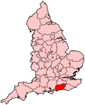
Arun is een Engels district in het shire-graafschap (non-metropolitan county OF county) West Sussex en telt 160.000 inwoners. De oppervlakte bedraagt 221 km².
| Niet-metropolitaans district in Engeland | |||
  | |||
| Situering | |||
| Land | Engeland | ||
| County | West Sussex | ||
| Regio | South East England | ||
| Coördinaten | 50°48'30"NB, 0°32'19"WL | ||
| Algemeen | |||
| Oppervlakte | 220,9323[1] km² | ||
| Inwoners (2018[2]) | 159827 (723 inw./km²) | ||
| ONS-code | E07000224 | ||
| |||
Van de bevolking is 26,0% ouder dan 65 jaar. De werkloosheid bedraagt 2,2% van de beroepsbevolking (cijfers volkstelling 2001).
Civil parishes in district Arun
Aldingbourne, Aldwick, Angmering, Arundel, Barnham, Bersted, Bognor Regis, Burpham, Clapham, Climping, East Preston, Eastergate, Felpham, Ferring, Findon, Ford, Houghton, Kingston, Littlehampton, Lyminster and Crossbush, Madehurst, Middleton-on-Sea, Pagham, Patching, Poling, Rustington, Slindon, South Stoke, Walberton, Warningcamp, Yapton.
Bronnen, noten en/of referenties
|
This article is issued from
Wikipedia.
The text is licensed under Creative
Commons - Attribution - Sharealike.
Additional terms may apply for the media files.