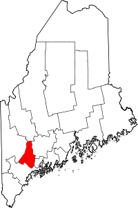
Androscoggin County
Androscoggin County is een county in de Amerikaanse staat Maine.
| County in de Verenigde Staten | |||
 | |||
| Situering | |||
| Staat | Maine | ||
| Coördinaten | 44°8'6,256"NB, 70°13'3,601"WL | ||
| Algemeen | |||
| Oppervlakte | 1.288 km² | ||
| - land | 1.218 km² | ||
| - water | 70 km² | ||
| Inwoners (2000) | 103.793 (85 inw./km²) | ||
| Overig | |||
| Zetel | Auburn | ||
| FIPS-code | 23001 | ||
| Foto's | |||
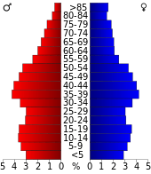 Bevolkingspiramide Androscoggin County | |||
| Statistieken volkstelling Androscoggin County | |||
| |||
De county heeft een landoppervlakte van 1.218 km² en telt 103.793 inwoners (volkstelling 2000). De hoofdplaats is Auburn.
Bevolkingsontwikkeling
| Historische inwonertallen | |||
|---|---|---|---|
| Jaar | Inwoners | % ± | |
| 1900 | 54.242 | ||
| 1910 | 59.822 | 10,3% | |
| 1920 | 65.796 | 10,0% | |
| 1930 | 71.214 | 8,2% | |
| 1940 | 76.679 | 7,7% | |
| 1950 | 83.594 | 9,0% | |
| 1960 | 86.312 | 3,3% | |
| 1970 | 91.279 | 5,8% | |
| 1980 | 99.657 | 9,2% | |
| 1990 | 105.259 | 5,6% | |
| 2000 | 103.793 | −1,4% | |
| Bron: (en) Historical Decennial Census Population | |||
Foto's
 Huizen
This article is issued from
Wikipedia.
The text is licensed under Creative
Commons - Attribution - Sharealike.
Additional terms may apply for the media files.