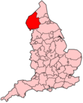
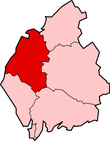
Allerdale
Allerdale is een Engels district in het graafschap Cumbria en telt 97.000 inwoners. De oppervlakte bedraagt 1242 km². Hoofdplaats is Workington.
| Niet-metropolitaans district in Engeland | |||
  | |||
| Situering | |||
| Land | Engeland | ||
| County | Cumbria | ||
| Regio | North West England | ||
| Coördinaten | 54°38'24"NB, 3°24'43"WL | ||
| Algemeen | |||
| Oppervlakte | 1241,6388[1] km² | ||
| Inwoners (2018[2]) | 97527 (76 inw./km²) | ||
| ONS-code | E07000026 | ||
| |||
Van de bevolking is 18,3% ouder dan 65 jaar. De werkloosheid bedraagt 3,9% van de beroepsbevolking (cijfers volkstelling 2001).
Civil parishes (63): Above Derwent, Aikton, Allhallows, Allonby, Aspatria, Bassenthwaite, Bewaldeth and Snittlegarth, Blennerhasset and Torpenhow, Blindbothel, Blindcrake, Boltons, Borrowdale, Bothel and Threapland, Bowness, Bridekirk, Brigham, Bromfield, Broughton, Broughton Moor, Buttermere, Caldbeck, Camerton, Cockermouth, Crosscanonby, Dean, Dearham, Dundraw, Embleton, Gilcrux, Great Clifton, Greysouthen, Hayton and Mealo, Holme Abbey, Holme East Waver, Holme Low, Holme St Cuthbert, Ireby and Uldale, Keswick, Kirkbampton, Kirkbride, Lands common to Holme Abbey, Holme Low and Holme St Cuthbert, Little Clifton, Lorton, Loweswater, Maryport, Oughterside and Allerby, Papcastle, Plumbland, Seaton, Sebergham, Setmurthy, Silloth-on-Solway, St John's Castlerigg and Wythburn, Thursby, Underskiddaw, Waverton, Westnewton, Westward, Wigton, Winscales, Woodside, Workington, Wythop.
Bronnen, noten en/of referenties
|