York, Toronto
York is a former city within the current city of Toronto, Ontario, Canada. It is located northwest of Old Toronto, southwest of North York and east of Etobicoke, where it is bounded by the Humber River. As a separate city, it was one of six municipalities that amalgamated in 1998 to form the current city of Toronto. The City of York was created by the amalgamation of several villages, including the present-day neighbourhoods of Lambton Mills and Weston.
York, Toronto | |
|---|---|
Dissolved municipality | |
| Motto(s): E singulis communitas (Latin for "From individuals, a community") | |
 Location of York (red), as compared with the rest of Toronto. | |
| Country | |
| Province | |
| Municipality | |
| Incorporated | 1793 (township) 1 January 1967 (borough) June 1983 (city) |
| Changed Region | 1954 |
| Amalgamated | 1 January 1998 into Toronto |
| Government | |
| • Councillors | Mike Colle, Joe Mihevc, Frances Nunziata, Cesar Palacio |
| • MPs | Carolyn Bennett, Julie Dzerowicz, Marco Mendicino, Ahmed Hussen |
| • MPPs | Laura Albanese, Mike Colle, Cristina Martins |
| Area | |
| • Total | 23.49 km2 (9.07 sq mi) |
| Population (2016)[1] | |
| • Total | 145,662 |
| • Density | 6,201/km2 (16,060/sq mi) |
| Time zone | UTC-5 (EST) |
| • Summer (DST) | UTC-4 (EDT) |
| Area code(s) | 416, 647, 437 |
History
York Township was incorporated by Canada West in 1850 (Canada West later became Ontario in 1867, due to Confederation), bounded in the west by the Humber River, in the east by what would become Victoria Park Avenue, and in the north by what would become Steeles Avenue. Etobicoke Township and Scarborough Township were located west and east, respectively, while the townships of Vaughan and Markham bordered on the north.
York Township was home to one of the original Black communities in the Toronto area, which was populated by many African American fugitive slaves.[1] By 1861, the township had the second-largest Black population in the Toronto area, after St. John's Ward, most of whom lived in York Township West (located west of Yonge Street and north of Bloor Street).[1] The legacy of York's original Black community continues today; as of the 2016 Census, 17% of York's population is Black, the largest percentage of all six former municipalities.[2]
Humewood-Cedarvale was developed in the 1910s to attract development in the growing township. Oakwood Village was also developed during this time. In the 1920s, the character of the township changed, with its southern reaches abutting the city of Toronto taking on a more urban character, compared with the very rural character of the north. The decision was made to split the township in two, with the northern, rural portion becoming North York in 1922. The remaining, two pockets of unincorporated urban development at the north end of the city, were split by the village of North Toronto, which was by then a part of the City of Toronto. Within years, the Province of Ontario saw that this arrangement of having an exclave was impractical, and further subdivided York, creating the township of East York out of the eastern pocket. The Township of York contracted streetcar and bus services from the Toronto Transportation Commission (later became Toronto Transit Commission in 1954), but remained independent from Toronto. During this time, American novelist Ernest Hemingway resided in the Humewood–Cedarvale community, writing for the Toronto Star.
North and west of Oakwood Village is the Fairbank community. Silverthorn is west of Fairbank. Silverthorn (and Fairbank) is described as "Toronto's hidden San Francisco" in reference to its "steep streets, staircases, and unusual views of houses built in what must be the hilliest part of the city."[3] This is due to Toronto's topography being shaped by its deep ravines being similar to the hills of San Francisco.
Another community in York, Mount Dennis, contained the former campus of Kodak, which is being repurposed for Line 5 Eglinton's Eglinton Maintenance and Storage Facility.
In 1954, York, along with other municipalities south of Steeles Avenue were severed from York County, forming the new upper-tier government of Metropolitan Toronto. In 1967, it absorbed the town of Weston, and became the Borough of York, later known as the City of York. (The map shows this area in red). York was amalgamated into the new City of Toronto on 1 January 1998. Its former council and administrative building, York Civic Centre, is located at 2700 Eglinton Avenue West, between Black Creek Drive and Keele Street.
Education
Four public school boards offers schooling to students residing in York, Conseil scolaire catholique MonAvenir (CSCM), Conseil scolaire Viamonde (CSV), the Toronto Catholic District School Board (TCDSB), and the Toronto District School Board (TDSB). CSV and TDSB operate as secular public school boards, the former operating French first language institution, whereas the latter operated English first-language institutions. The other two school boards, CSCM and TCDSB, operate as public separate school boards, the former operating French first language separate schools, the latter operating English first language separate schools.
Before York was amalgamated with the rest of Metropolitan Toronto, the York Board of Education oversaw public secular schools in the former city. As with the other school boards in Metro Toronto, they were amalgamated to form TDSB in 1998. Presently, the school board operates several institutions that offer primary and secondary education. Secondary schools in York that are operated by TDSB include:
- Frank Oke Secondary School
- George Harvey Collegiate Institute
- Oakwood Collegiate Institute (albeit located within Old Toronto proper, but its catchment area includes much of the eastern half of York since the closure of Vaughan Road Academy)
- Weston Collegiate Institute
- York Memorial Collegiate Institute
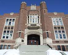
TDSB formerly operated another secondary school in York, Vaughan Road Academy. Opened in 1927, the secondary school was York's first but was closed on its 90th anniversary in 2017 due to its lack of student population resulting from students in the local catchment area attending other nearby high schools. Vaughan Road Academy is repurposed as a temporary elementary school for students in the Yonge and Davisville area in Midtown Toronto since the 2018–19 school year to accommodate the construction of a new school building.[4][5]
TCDSB operates one secondary school in York, St. Oscar Romero Catholic Secondary School. Neither CSCM or CSV operate a secondary school in York, with CSV/CSCM students residing in York attending secondary schools located in adjacent districts of Toronto.
Infrastructure
Public library system
Presently, the Toronto Public Library operates several branches within York. Prior to York's amalgamation of Toronto in 1997, the city operated its own library system, known as York Public Library. As a result of amalgamating the municipalities in Metropolitan Toronto, York Public Library was merged with the other library systems of the new City of Toronto to form the new Toronto Public Library.
York's first public library was the Mount Dennis branch, which operated out of rented premises since 1923.[6] In 1945, the Township of York Public Library Board was established, and proceeded to build three new library buildings that opened in 1951, including the Jane/Dundas library, Main Library (Eglinton Avenue near Dufferin Street), and the Mount Dennis Library.[6][7][8] The Main Library was later renamed after head librarian Maria Shchuka and was later rebuilt in 2003. The Oakwood Village branch was York's newest library; opening a year before the municipalities of Metropolitan Toronto amalgamated.
Public transit
York is served by the Toronto Transit Commission's buses, streetcar, and subway system. Early in the community history, York had operated its own bus and streetcar service, until it was absorbed by the Toronto Transit Commission. Of the Toronto subway system, only the Heath Street exit of St. Clair West station on Line 1 Yonge–University is in the former city of York. The Rogers Road streetcar line served the namesake street as well.
Line 5 Eglinton
The TTC once had plans to construct the Eglinton West subway line along Eglinton Avenue in the former city of York. However, it was cancelled in 1995 under premier Mike Harris and there had been no serious discussion about reviving the line until 2007, when Line 5 Eglinton (then known as the Eglinton Crosstown LRT) was proposed as part of Transit City.
When Rob Ford became mayor in 2010, he immediately announced the cancellation of Transit City. However, city council spared a few lines, including the Eglinton Crosstown LRT, from cancellation, despite Ford's objections.
Since 2013, the new LRT is being constructed and is expected to be opened in 2022.
GO Transit

The Weston GO Station along the Kitchener line is the only GO Transit train station within the former city of York. There are also plans to construct the Caledonia GO Station along the Barrie line, which would connect with Line 5's Caledonia station, along with the Mount Dennis GO Station along the Kitchener line to connect with Line 5's Mount Dennis station.
Politics
York was formerly an incorporated municipality, now a part of the City of Toronto. The community was first incorporated as a township in 1793. The township was initially a township under the County of York until 1954. In 1954 York was formally severed from the county, along with other municipalities situated south of Steeles Avenue to form the upper-tier government of Metropolitan Toronto. In 1967, the township was formally made into a borough of Metropolitan Toronto, and later a city in 1983. In 1997, York, along with the remaining municipalities of Metropolitan Toronto were formally amalgamated to form the new City of Toronto.
On a provincial and federal level of governance, eligible residents of York are also able to vote for members of the Parliament of Canada, and the Legislative Assembly of Ontario. Additionally, as a part of the City of Toronto, York takes part in Toronto municipal elections, with eligible residents able to vote on the Mayor of Toronto, as well as councillors to the Toronto City Council. Prior to York's amalgamation with Toronto, York operated its own municipal council, with a mayor heading York's council. Prior to the municipality's incorporation as a borough, the chief magistrate of the council was referred to as a reeve.
The following individuals served as the reeves of the Township of York:
- George Stewart Henry (1906–1910)
- R.J. Stuart (1934–1935)
- W. Marsh Magwood (1936–1937)
- F.J. MacRae (1938–1946)
- C.J. McMaster (1947–1948)
- William George Beech (1949–1951)
- Fred W. Hall (1952–1956)
- Chris A. Tonks (1957–1960)
- Fred C. Taylor (1961)
- Walter Saunders (1962)
- Jack Mould (1963–1966)
The following individuals served as York's mayor:
- Jack Mould (1966–1969)
- Philip White (1970–1978)
- Gayle Christie (1978–1982)
- Alan Tonks (1982–1988)
- Fergy Brown (1988–1994)
- Frances Nunziata (1994–1997)
The following individuals served as the Deputy Mayor of York:
- Joe Mihevc (1991–1997)
The following individuals served on York's Board of Control:
Names in boldface indicate Controllers that were or became Mayor of York in other years.
X = elected as Controller
A = appointed Controller to fill a vacancy
M = sitting as Reeve or Mayor
| Controller | 1969 | 1972 | 1974 | 1976 | 1978 | 1980 | 1982 | 1985 |
|---|---|---|---|---|---|---|---|---|
| Philip White | M | M | M | M | X | X | X | |
| James Trimbee | X | X | X | |||||
| Doug Saunders | X | X | X | X | ||||
| Alan Tonks | X | X | M | M | ||||
| Gayle Christie | M | M | ||||||
| Fergy Brown* | X | X | X | X |
*Brown served as mayor from 1988 to 1994
See also
- List of neighbourhoods in York
- History of neighbourhoods in Toronto
References
- Reverend Mitchell Harriet Tubman Institute. Accessed on 28 February 2016.
- https://www.toronto.ca/city-government/data-research-maps/neighbourhoods-communities/neighbourhood-profiles/
- Micallef, Shawn (26 September 2014). "A walk with Ward 12 candidate Lekan Olawoye". Toronto Star. Retrieved 14 June 2018.
- "New School". 10 May 2011.
- http://schoolweb.tdsb.on.ca/Portals/davisville/docs/Davisville%20Relocation-Mar18BULLETIN%20V2.ppt
- "History". Mount Dennis. Toronto: Toronto Public Library. 2012. Retrieved 25 November 2012.
- "History". Jane/Dundas. Toronto: Toronto Public Library. 2012. Retrieved 25 November 2012.
- "History". Maria Shchuka. Toronto: Toronto Public Library. 2012. Retrieved 25 November 2012.
External links
| Wikimedia Commons has media related to York, Toronto. |