Petropavlovsk-Kamchatsky
Petropavlovsk-Kamchatskiy (Russian: Петропа́вловск-Камча́тский, tr. Petropavlovsk-Kamchatskiy, IPA: [pʲɪtrɐˈpavləfsk kɐmˈtɕatskʲɪj] (![]()
Petropavlovsk-Kamchatskiy Петропавловск-Камчатский | |
|---|---|
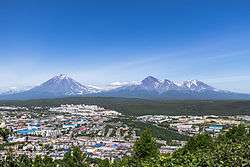 Aerial view of Petropavlovsk-Kamchatskiy with the Koryaksky volcano | |
.png) Flag  Coat of arms | |
Location of Petropavlovsk-Kamchatskiy 
| |
 Petropavlovsk-Kamchatskiy Location of Petropavlovsk-Kamchatskiy 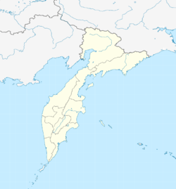 Petropavlovsk-Kamchatskiy Petropavlovsk-Kamchatskiy (Kamchatka Krai) | |
| Coordinates: 53°01′N 158°39′E | |
| Country | Russia |
| Federal subject | Kamchatka Krai |
| Founded | October 17, 1740 |
| Government | |
| • Body | City Duma |
| • Head | Sergey Kondrashin |
| Area | |
| • Total | 362.14 km2 (139.82 sq mi) |
| Elevation | 150 m (490 ft) |
| Population | |
| • Total | 179,780 |
| • Estimate (2018)[3] | 181,216 (+0.8%) |
| • Rank | 100th in 2010 |
| • Density | 500/km2 (1,300/sq mi) |
Administrative status | |
| • Subordinated to | Petropavlovsk-Kamchatskiy City Under Krai Jurisdiction[1] |
| • Capital of | Kamchatka Krai[1], Petropavlovsk-Kamchatskiy City Under Krai Jurisdiction[1] |
Municipal status | |
| • Urban okrug | Petropavlovsk-Kamchatskiy Urban Okrug[4] |
| • Capital of | Petropavlovsk-Kamchatskiy Urban Okrug[4] |
| Time zone | UTC+12 (MSK+9 |
| Postal code(s)[6] | 683000 (main) |
| Dialing code(s) | +7 4152 |
| OKTMO ID | 30701000001 |
| City Day | October 17 |
| Twin towns | Kushiro, Sevastopol, Unalaska, Aksaray |
| Website | pkgo |
The city is widely known simply as Petropavlovsk (literally "city of Peter and Paul"). The adjective Kamchatsky ("Kamchatkan") was added to the official name in 1924.
Geography
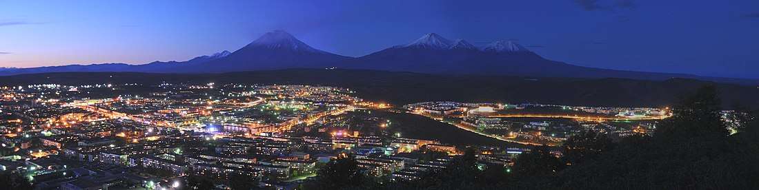
The city is situated on high hills and surrounded by volcanoes. The surrounding terrain is mountainous enough that the horizon cannot be seen clearly from any point in town. Across Avacha Bay from the city in Vilyuchinsk is Russia's largest submarine base, the Rybachiy Nuclear Submarine Base, established during the Soviet period and still used by the Russian Navy.[7] The city is located 6,766 kilometres (4,204 mi) from Moscow and about 2,220 kilometres (1,380 mi) from Vladivostok.
History
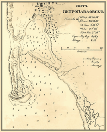
Cossack units visited the area from 1697. The explorer and navigator Captain Vitus Bering (a Dane in the service of the Imperial Russian Navy) is considered to be have founded the city in 1740, although navigator Ivan Fomich Yelagin had laid the foundation a few months earlier. Bering reached Avacha Bay in late 1740 and in his capacity as the superior officer, named the new settlement "Petropavlovsk" (Peter and Paul) after his two ships, the St. Peter and the St. Paul, which had been built in Okhotsk for his second expedition of 1733–1742. The town's location on the eastern coast of the Kamchatka Peninsula, on the sheltered Avacha Bay and at the mouth of the Avacha River, saw it develop to become the most important settlement in Kamchatka. It gained town status on April 9, 1812.
During the 1853–1855 Crimean War, Anglo-French forces put the city under siege (August-September 1854), but it never fell. The city had been fortified under the overall command of Nikolay Muravyov ( Governor-General of the Eastern Siberia Governorate-General from 1847 to 1861) in the preceding years, but possessed only a small garrison of a few hundred soldiers and sixty-seven cannon. After much exchange of fire, six hundred Anglo-French troops landed south of the city; two hundred and thirty Russian troops forced them to retreat after heavy fighting (1 September 1854). Four days later, a larger force of nine hundred Anglo-French troops landed east of the town, but again the Russians repelled the allies (5 September 1854). The allied ships then retreated from Russian Pacific waters (7 September 1854). The total Russian losses were reported at around a hundred men; the Anglo-French were said to have lost at least five times that number.[8]
At the time of the surrender of Japan in World War II (August/September 1945), United States Naval Construction Battalion 114 was in the Aleutians. In September 1945 the battalion received orders to send a detachment to the USSR to build a Naval Advance Base (a Fleet Weather Central)[9] – located ten miles outside Petropavlovsk-Kamchatskiy and code-named TAMA.[10] The original agreement gave the Seabees three weeks to complete the camp. Upon arrival the Soviets told the Seabees they had ten days, and were amazed that the Seabees achieved the task.[10] It was one of two that Stalin agreed to. The other was near Khabarovsk, in buildings provided by the Russians.[10] For mail Petropavlovsk was assigned Navy number 1169, FPO San Francisco.[11] The American use of these two bases proved short-lived.
Petropavlovsk was a great source of fish, particularly salmon, and crab meat for the Soviet Union in the 20th century. Following the end of the Soviet era in December 1991, fishing rights have also been granted to foreign interests. Poaching of salmon for their caviar at Petropavlovsk-Kamchatskiy remains a problem amid lax law-enforcement and widespread corruption.[12]
Association football has a history in Petropavlovsk-Kamchatskiy. The main stadium in Petropavlovsk-Kamchatskiy is the 5,000-capacity Spartak Stadium – used mostly for association-football matches. The former association-football club FC Volcano were tenants of the stadium.
Administrative and municipal status
Petropavlovsk-Kamchatskiy is the administrative center of the krai.[1] Within the framework of administrative divisions, it is incorporated as Petropavlovsk-Kamchatskiy City Under Krai Jurisdiction—an administrative unit with the status equal to that of the districts.[1] As a municipal division, Petropavlovsk-Kamchatskiy City Under Krai Jurisdiction is incorporated as Petropavlovsk-Kamchatskiy Urban Okrug.[4]
Tourism
The city has developed a tourist infrastructure. About twenty large tourism companies offer a wide range of services from bear hunting to paragliding. No roads connect the Kamchatka Peninsula to the rest of the world. Travel to Petropavlovsk-Kamchatskiy is expensive but is growing in popularity because of the remarkable scenery throughout the peninsula. The city is served by Petropavlovsk-Kamchatsky Airport, which is linked to the town and its port via the A-401 road. During the warmer months cruise ships regularly stop there for the day.
Demographics
Ethnic Russians make up the majority of the population; the city on its own has more inhabitants than the entire neighboring Chukotka Autonomous Okrug or Magadan Oblast.
The population numbered 179,780 in 2010; 179,800 in 2011; 179,784 in 2012; and 181,618 in 2013.
Climate
The climate at Petropavlovsk-Kamchatskiy reasonably qualifies as cool-summer continental (Köppen Dfc). However, this area's climate has strong oceanic influences due its proximity to the Sea of Okhotsk. Therefore, the climate is transitional between the subpolar oceanic climates of the (Alaska, U.S.) Aleutian Islands to the east and the strongly continental subarctic climate prevalent in northeast Russia, whether at coastal locations (i.e. Magadan) or interior areas (with extreme hypercontinental, subarctic climates, such as Yakutsk and especially Verkhoyansk). Average annual precipitation is 1,180 millimeters (46 in), or about 3 1⁄2 times as much as most of Siberia averages, mostly falling as frozen precipitation, primarily snow, from November to April. Average monthly precipitation is highest in autumn, with October the wettest month on average, closely followed by November. May through July are markedly the driest months on average; June is the single driest month. Winter temperatures are much milder than in Siberia. Here, average January daytime high temperatures are around −4.4 °C (24.1 °F), while average daytime high temperature in August, the warmest month, is 17 °C (63 °F). Thus, resulting from oceanic cooling, summer daytime high temperatures in Petropavlovsk-Kamchatskiy are markedly cooler than in interior Siberia, where Verkhoyansk has a July average daytime high temperature of 23.5 °C (74.3 °F). In warmer-summer years, monthly high averages in July–August can reach 18 °C (64 °F) and higher. Days of above 20 °C (68 °F) can be expected an average of 19.6 days per summer.[13]
Despite the generally high precipitation, the weather is less cloudy than in the adjacent Kuril Islands that are one of the least sunny places in the world,[14] since the city is located behind a peninsula to the north that blocks some of the fog from the cold Oyashio Current offshore of the Kamchatka Peninsula. Oceanic water in Avacha Bay and adjacent bays is also warmer than coastal waters of Kuril Islands and Okhotsk sea coast (except Southern Kuriles and Southern Sakhalin).
In the spring (February to April), seawater may freeze.
Highest Temperature: 30.0 °C (86.0 °F) on July 2, 2012
Lowest Temperature: −31.7 °C (−25.1 °F) on February 14, 1917
Warmest Month: 16.1 °C (61.0 °F) on July, 2013
Coldest Month: −22.1 °C (−7.8 °F) on February, 1898
Highest Daily Precipitation: 200.2 millimetres (7.88 in) on November 10, 2002
Wettest Year: 1,996 millimetres (78.6 in) in 1971
Driest Year: 432 millimetres (17.0 in) in 1947
| Climate data for Petropavlovsk-Kamchatskiy (1981–2010, extremes 1894–present Climate ID:32583) | |||||||||||||
|---|---|---|---|---|---|---|---|---|---|---|---|---|---|
| Month | Jan | Feb | Mar | Apr | May | Jun | Jul | Aug | Sep | Oct | Nov | Dec | Year |
| Record high °C (°F) | 5.2 (41.4) |
6.2 (43.2) |
7.1 (44.8) |
18.8 (65.8) |
20.6 (69.1) |
26.9 (80.4) |
30.0 (86.0) |
27.7 (81.9) |
24.4 (75.9) |
19.4 (66.9) |
12.6 (54.7) |
10.5 (50.9) |
30.0 (86.0) |
| Average high °C (°F) | −4.4 (24.1) |
−3.7 (25.3) |
−0.8 (30.6) |
3.3 (37.9) |
8.2 (46.8) |
13.5 (56.3) |
16.5 (61.7) |
17.0 (62.6) |
14.1 (57.4) |
8.4 (47.1) |
1.7 (35.1) |
−2.9 (26.8) |
5.9 (42.6) |
| Daily mean °C (°F) | −7.0 (19.4) |
−6.3 (20.7) |
−3.8 (25.2) |
0.3 (32.5) |
4.5 (40.1) |
9.4 (48.9) |
12.7 (54.9) |
13.4 (56.1) |
10.4 (50.7) |
5.5 (41.9) |
−0.8 (30.6) |
−5.1 (22.8) |
2.8 (37.0) |
| Average low °C (°F) | −9.2 (15.4) |
−8.8 (16.2) |
−6.3 (20.7) |
−2.0 (28.4) |
1.9 (35.4) |
6.4 (43.5) |
10.0 (50.0) |
10.8 (51.4) |
7.5 (45.5) |
3.1 (37.6) |
−2.8 (27.0) |
−7.3 (18.9) |
0.3 (32.5) |
| Record low °C (°F) | −28.6 (−19.5) |
−31.7 (−25.1) |
−24.8 (−12.6) |
−14.8 (5.4) |
−6.3 (20.7) |
−1.5 (29.3) |
2.5 (36.5) |
4.4 (39.9) |
−1.1 (30.0) |
−7.5 (18.5) |
−16.5 (2.3) |
−26.0 (−14.8) |
−31.7 (−25.1) |
| Average precipitation mm (inches) | 118 (4.6) |
80 (3.1) |
84 (3.3) |
90 (3.5) |
64 (2.5) |
53 (2.1) |
62 (2.4) |
91 (3.6) |
112 (4.4) |
172 (6.8) |
145 (5.7) |
109 (4.3) |
1,177 (46.3) |
| Average rainy days | 1 | 0.4 | 1 | 3 | 13 | 15 | 17 | 17 | 17 | 17 | 6 | 1 | 108 |
| Average snowy days | 18 | 18 | 18 | 17 | 7 | 0.1 | 0 | 0 | 0.03 | 3 | 15 | 17 | 113 |
| Average relative humidity (%) | 71 | 68 | 68 | 72 | 75 | 79 | 84 | 83 | 79 | 74 | 70 | 71 | 75 |
| Mean monthly sunshine hours | 105 | 114 | 176 | 192 | 193 | 196 | 169 | 178 | 178 | 157 | 122 | 93 | 1,870 |
| Source #1: Pogoda.ru.net[15] | |||||||||||||
| Source #2: NOAA (sun 1961–1990)[16] | |||||||||||||
| Climate data for Petropavlovsk-Kamchatskiy | |||||||||||||
|---|---|---|---|---|---|---|---|---|---|---|---|---|---|
| Month | Jan | Feb | Mar | Apr | May | Jun | Jul | Aug | Sep | Oct | Nov | Dec | Year |
| Average sea temperature °C (°F) | 0.1 (32.2) |
-0.6 (30.9) |
-0.5 (31.1) |
-0.2 (31.6) |
2.2 (36.0) |
6.8 (44.2) |
10.3 (50.5) |
12.3 (54.1) |
10.3 (50.5) |
7.3 (45.1) |
4.8 (40.6) |
1.8 (35.2) |
4.6 (40.3) |
| Source: Weather Atlas [17] | |||||||||||||
Politics
Results of the Russian legislative elections
| Parties/Year | 2003 | 2007 | 2011 |
|---|---|---|---|
| Communist Party | 8.83% | 8.89% | 17.78% |
| Patriots of Russia (including former Party of Peace and Unity) |
0.35% | 2.31% | 2.53% |
| A Just Russia (including former Rodina or Motherland-National Patriotic Union Russian Party of Life People's Party of the Russian Federation and Russian Ecological Party "The Greens") |
13.91% | 7.41% | 9.93% |
| Yabloko (including former Union of People for education and research: "Партия СЛОН") |
8.92% | 1.85% | 5.10% |
| Right Cause (including former Citizens' Force Democratic Party of Russia and Union of Rightist Forces) |
4.46% | 2.74% | 0.67% |
| United Russia (including former Agrarian Party of Russia) |
35.29% | 61.78% | 43.59% |
| Liberal Democratic Party | 15.25% | 12.00% | 18.40% |
| Other minor parties | 12.12% |
Twin towns – sister cities
Petropavlovsk-Kamchatskiy is twinned with:[18]
Notable residents
- Pavlo Ishchenko, Ukrainian-Israeli Olympic boxer
- Anatolii Mohyliov, Ukrainian politician
- Sergei Ursuliak, Russian filmmaker, screenwriter and actor, and TV presenter
- Elena Yakovishina, Russian Olympic skier
Gallery
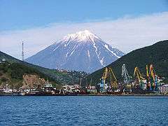 Petropavlovsk and Koryaksky Volcano, as seen from Avacha Bay
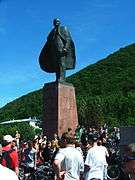 Lenin Square
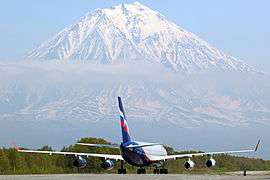 An Ilyushin Il-96-300 of Aeroflot at Petropavlovsk-Kamchatskiy Airport
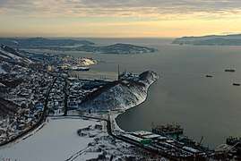 Original town center
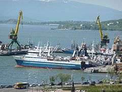 Seaport
 Sovetskaya Street
 Ski resort "Red Hill" ("Krasnaya Sopka") in Petropavlovsk-Kamchatskiy
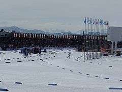 Petropavlovsk-Kamchatskiy biathlon stadium. Vitaly Fatyanov prize competition.
 Aerial view of Petropavlovsk
 A Chapel, dedicated to those killed in the defense of the city in 1854.
References
- Law #46
- Russian Federal State Statistics Service (2011). "Всероссийская перепись населения 2010 года. Том 1" [2010 All-Russian Population Census, vol. 1]. Всероссийская перепись населения 2010 года [2010 All-Russia Population Census] (in Russian). Federal State Statistics Service.CS1 maint: ref=harv (link)
- http://www.gks.ru/free_doc/doc_2018/bul_dr/mun_obr2018.rar; archive date: 26 July 2018; retrieved: 25 July 2018; archive URL: https://web.archive.org/web/20180726010024/http://www.gks.ru/free_doc/doc_2018/bul_dr/mun_obr2018.rar.
- Law #220
- "Об исчислении времени". Официальный интернет-портал правовой информации (in Russian). June 3, 2011. Retrieved January 19, 2019.
- Почта России. Информационно-вычислительный центр ОАСУ РПО. (Russian Post). Поиск объектов почтовой связи (Postal Objects Search) (in Russian)
- "Archived copy". Archived from the original on November 6, 2011. Retrieved December 11, 2011.CS1 maint: archived copy as title (link)
- Black, Jeremy (2001). Western warfare 1775–1882. Bloomington: Indiana University Press. p. 80. ISBN 978-0-253-21472-0.
- The 114th CB cruisebook, 1946, U.S.Navy Seabee Museum Archives, Port Hueneme, Ca, p.123-125
- "Yanks in Siberia: U.S. Navy Weather Stations in Soviet East Asia, 1945," G. Patrick March, Pacific Historical Review, Vol. 57, No. 3 (Aug., 1988), pp. 327–342, Published by: University of California Press.
- US Navy Abbreviations of World War II,The Navy Department Library, U.S. Navy web site, Published:Thu Jul 23 2015
- Feifer, Gregory (July 22, 2007). "Poaching in Far Eastern Russia Threatens Ecosystem". NPR. Archived from the original on May 9, 2015. Retrieved June 29, 2014.
- "Archived copy". Archived from the original on June 1, 2012. Retrieved December 2, 2011.CS1 maint: archived copy as title (link) Hydrometeorological Centre of Russia
- See Climatological Norms of Simusir Island Archived September 24, 2012, at the Wayback Machine
- "Weather and Climate-The Climate of Petropavlovsk-Kamchatskiy" (in Russian). Weather and Climate (Погода и климат). Archived from the original on December 1, 2019. Retrieved December 1, 2019.
- "Petropavlovsk-Kamca Climate Normals 1961–1990". National Oceanic and Atmospheric Administration. Retrieved December 1, 2019.
- "Petropavlovsk-Kamchatskiy, Russia - Monthly weather forecast and Climate data". Weather Atlas. Retrieved November 11, 2019.
- "Города-побратимы". pkgo.ru (in Russian). Petropavlovsk-Kamchatskiy. Retrieved February 5, 2020.
Sources
- Законодательное Собрание Камчатского края. Закон №46 от 29 апреля 2008 г. «Об административно-территориальном устройстве Камчатского края», в ред. Закона №659 от 30 июля 2015 г. «О внесении изменения в статью 5 Закона Камчатского края "Об административно-территориальном устройстве Камчатского края"». Вступил в силу со дня официального опубликования. Опубликован: "Официальные Ведомости", №65-69, 6 мая 2008 г. (Legislative Assembly of Kamchatka Krai. Law #46 of April 29, 2008 On the Administrative-Territorial Structure of Kamchatka Krai, as amended by the Law #659 of July 30, 2015 On Amending Article 5 of the Law of Kamchatka Krai "On the Administrative-Territorial Structure of Kamchatka Krai". Effective as of the day of the official publication.).
- Совет народных депутатов Камчатской области. Закон №220 от 20 октября 2004 г. «О наделении Петропавловск-Камчатского городского муниципального образования статусом городского округа и об установлении границ Петропавловск-Камчатского городского округа». Вступил в силу со дня официального опубликования. Опубликован: "Официальные Ведомости", №77–78, 16 декабря 2004 г. (Council of People's Deputies of Kamchatka Oblast. Law #220 of October 20, 2004 On Granting Urban Okrug Status to Petropavlovsk-Kamchatsky Urban Municipal Formation and on Establishing the Borders of Petropavlovsk-Kamchatsky Urban Okrug. Effective as of the day of the official publication.).
External links
| Wikivoyage has a travel guide for Petropavlovsk-Kamchatskiy. |
| Wikisource has the text of an 1879 American Cyclopædia article about Petropavlovsk-Kamchatskiy. |
- Official website of Petropavlovsk-Kamchatskiy (in Russian)
- New photos of the city (in Russian)
- Photos of Kamchatka (in Russian)
- News of Petropavlovsk-Kamchatskiy and Kamchatka Krai (in Russian)
- Petropavlovsk-Kamchatskiy Internet portal (in Russian)
- History of the city of Petropavlovsk-Kamchatskiy (in Russian)
| Authority control |
|
|---|