Perthshire
Perthshire (/ˈpɜːrθʃər/ (![]()
| Perthshire | |
|---|---|
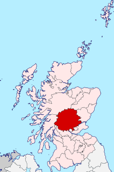 Perthshire within Scotland | |
| Area | |
| • 1975 | 2528 sq. miles (6547 sq. km) (5th) |
| History | |
| • Succeeded by | Tayside Region |
| Status | Local government county (until 1975) Land registration county (1996 - ) |
| Chapman code | PER |
| Government | County: Perthshire County Council (1890-1929) Perth and Kinross County Council (1929-1975) Modern: Perth and Kinross Council (1996 - ) Lieutenancy: Lord Lieutenant of Perth and Kinross |
| • HQ | Perth (county town and administrative centre) |
| • Motto | Pro Lege et Libertate ('For Law and Liberty') |
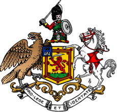 Coat of arms of the county council | |
Perthshire is known as the “big county”, owed to its roundness and status as the 4th largest historic county in Scotland. It has a wide variety of landscapes, from the rich agricultural straths in the east, to the high mountains of the southern Highlands.
Administrative history
Perthshire was an administrative county between 1890 and 1975, governed by a county council. From 1930 onwards, a joint local government council was formed with the small neighbouring county of Kinross-shire, linking the two.
In 1975, the administrative county was superseded by the Local Government (Scotland) Act 1973 and split between the Central and Tayside Regions:
- West Perthshire (the area west and south of Killin including Callander, Crianlarich and Aberfoyle) was included in the Stirling District of the Central Region.
- The parish of Muckhart and Glendevon was made part of Clackmannan District Council, also in the Central Region.
- Longforgan was included in the City of Dundee District, in the Tayside Region.
- The remainder of Perthshire was combined with Kinross-shire and the Angus parish of Kettins to form the Perth and Kinross District Council in Tayside.
The two-tier system introduced in 1975 was superseded by a system of unitary authorities in 1996. The districts of Tayside and Central Scotland all became unitary authorities, with Longforgan being transferred from Dundee to Perth and Kinross. The majority of historic Perthshire lies in Perth and Kinross. The exceptions are the southwestern part that is now in the Stirling council area and a few parishes that are now in Clackmannanshire. Perth and Kinross also contains some areas that were not historically in Perthshire, such as Kinross-shire. The lieutenancy areas in the same area are mostly coterminous with the council areas. Perthshire still exists as a registration county.
Boundaries
Prior to the 1890s Perthshire’s boundaries were irregular: the parishes of Culross and Tulliallan formed an exclave some miles away from the rest of the county, on the boundaries of Clackmannanshire and Fife; while the northern part of the parish of Logie formed an enclave of Stirlingshire within the county.
Following the recommendations of the council boundary commission appointed under the Local Government (Scotland) Act 1889, Culross and Tulliallan were transferred to Fife, and the entire parish of Logie was included in Stirlingshire.
Coat of arms
The coat of arms of the County of Perth appears to have been granted for use on the colours and standards of the volunteer and militia units of the county raised at the end of the eighteenth century. The Earl of Kinnoull, a native of Perthshire, and commanding officer of the Perthshire Gentlemen and Yeomanry Cavalry, was also Lord Lyon King of Arms at the time, and he presented the arms to the county in 1800. The grant document was discovered in the Lyon Office in 1890, and forwarded to the newly formed Perth County Council.
The shield is very similar to the Scottish royal arms, reflecting that Perthshire was the home county of the House of Dunkeld and contains the former royal capital, Scone. Further royal references are made on the canton, which shows Scone Palace surmounted by the Crown of Scotland. The crest is a Highland soldier, reflecting that the famous Black Watch were formed in the county.[1] The supporters are an eagle and a warhorse, the former from the arms of the city of Perth.
Burghs
By the 1890s the county contained the following burghs, which were largely outside the county council’s jurisdiction:
- Royal Burgh of Perth (which was styled a city)
- Burgh of Auchterarder (formed 1894: reinstated as a royal burgh in 1951)
- Burgh of Aberfeldy (police burgh from 1887)
- Burgh of Abernethy (burgh of barony from 1458/9, police burgh from 1877)
- Burgh of Alyth (police burgh 1834)
- Burgh of Blairgowrie (burgh of barony 1634, police burgh 1833)
- Burgh of Rattray (police burgh 1873)
- Burgh of Callander (police burgh 1866)
- Burgh of Coupar Angus (burgh of barony 1607, police burgh 1852)
- Burgh of Crieff (burgh of barony 1674, burgh of regality 1687, police burgh 1864)
- Burgh of Doune (burgh of barony 1611, police burgh 1890)
- Burgh of Dunblane (burgh of regality of the Bishop of Dunblane 1442, police burgh 1870)
The Local Government (Scotland) Act 1929 divided burghs into two classes from 1930: large burghs, which were to gain extra powers from the county council, and small burghs which lost many of their responsibilities.
Of the twelve burghs in Perthshire, only Perth was made a large burgh. There were ten small burghs: Blairgowrie and Rattray being united into a single burgh. In 1947 Pitlochry was created a small burgh.
Civil parishes

In 1894 parish councils were established for the civil parishes, replacing the previous parochial boards. The parish councils were in turn replaced by district councils in 1930.
Following the boundary changes caused by the Local Government (Scotland) Act 1889, the county contained the following civil parishes:
|
|
|
|
Districts
In 1930 the landward area of the Local Government councils (the part outside of burgh boundaries) was divided into five districts, replacing the parish councils established in 1894:
- Central District
- Eastern District
- Highland District
- Perth District
- Western District
Geography

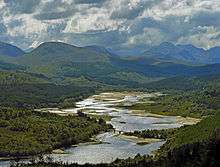
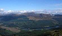
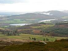
The county forms part of the Highland geographic area; it consists of predominantly mountainous and hilly land within the Grampian Mountains, interspersed with numerous lochs and glens. The highest point is Ben Lawers at 1,214 m (3,983 ft), making it the 4th highest peak in Scotland.[3] Most towns are fairly small, with the larger ones being clustered in the flatter south-east of the county. In the far south along the borders with Clackmannanshhire and Kinross-shire lie the Ochil Hills, and in the south-east part of the Sidlaw Hills lie within the county, continuing on into Angus. Perthshire borders the Firth of Tay in the south-east, which provides access to the North Sea; along the north shore lies the Carse of Gowrie, an extremely flat area of land given over to agriculture. Within the Forth can be found the small island of Mugdrum.
Rivers
- River Ardle
- River Earn
- River Ericht
- River Farg
- River Forth
- River Garry
- River Isla
- River Tay
- River Teith
- River Tummel
Lochs and Reservoirs
- Cally Loch
- Carsebreck Loch
- Castlehill Reservoir
- Cocksburn Reservoir (shared with Stirlingshire)
- Dowally Loch
- Drumore Loch
- Dubh Lochan
- Dupplin Loch
- Fingask Loch
- Glas Finglas Reservoir
- Glenfarg Reservoir (shared with Kinross-shire)
- Glenquey Resrvoir
- Glensherup Reservoir
- Laird’s Loch
- Lake of Menteith
- Little Loch Skiach
- Loch Achray
- Loch an Daimh
- Loch an Duin
- Loch Ard
- Loch Beanie
- Loch Benachally
- Loch Bollachan
- Loch Broom
- Loch Chon
- Loch Con
- Loch Crannach
- Loch Creagh
- Loch Curran
- Loch Derculich
- Loch Dhu
- Loch Doine
- Loch Drunkie
- Loch Earn
- Loch Eigeach
- Loch Ericht (shared with Inverness-shire)
- Loch Errochty
- Loch Essan
- Loch Farleyer
- Loch Fender
- Loch Finnart
- Loch Freuchie
- Loch Garry
- Loch Glassie
- Loch Hoil
- Loch Iubhair
- Loch Katrine (shared with Dunbartonshire)
- Loch Kennard
- Loch Kinardochy
- Loch Laddon (shared with Argyllshire)
- Loch Laggan
- Loch Lednock Reservoir
- Loch Loch
- Loch Lubnaig
- Loch Lyon
- Loch Macanrie
- Loch Maragan
- Loch Mhairc
- Loch Monaghan
- Loch Monzievaird
- Loch na Bà
- Loch na Brae
- Loch nan Eun
- Loch of Belloch
- Loch of Butterstone
- Loch of Clunie
- Loch of Craiglush
- Loch of Drumellie
- Loch of Lowes
- Loch Ordie
- Loch Oss
- Loch Rannoch
- Loch Rusky
- Loch Scoly
- Loch Skiach
- Loch Tay
- Loch Tilt
- Loch Tinker
- Loch Tummel
- Loch Turret Reservoir
- Loch Valigan
- Loch Venachar
- Loch Voil
- Loch Watston
- Lochan a' Chait
- Lochan a' Mhàidseir
- Loch Balloch
- Lochan Caol Fada
- Lochan Coire na Mèinne
- Lochan Creag a' Mhadaidh
- Lochan Ghiubhais
- Lochan Lairig Laoigh
- Lochan Lòin nan Donnlaich
- Lochan Mhàim nan Carn
- Lochan Mon' an Fhiadhain
- Lochan na Beinne
- Lochan na Làirige
- Lochan nam Breac
- Lohan nan Cat
- Lochan Oisinneach
- Lochan Oisinneach Mòr
- Lochan Ruighe nan-Sligean
- Lochan Spling
- Lochan Sròn Smeur
- Lochan Uaine
- Lossburn Reservoir
- Lower Glendevon Reservoir
- Lower Rhynd
- Methven Loch
- Mill Dam
- Monk Myre
- Pitcairnie Loch
- Pitcarmick Loch
- Pond of Drummond
- Rae Loch
- Redmyre Loch
- Rotmell Loch
- Seamaw Loch
- Stronuich Reservoir
- Stormont Loch
- Upper Glendevon Reservoir (shared with Clackmannanshire)
- Upper Rhynd
- Waltersmuir Reservoir
- White Loch
- White Moss Loch
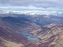
Mountains
.jpg)
- Ben Lawers
- Ben Vorlich
- Ben Mhor
- Ben Vrackie
- Beinn a' Ghlò
- Schiehallion
Glens and straths
- Glen Almond
- Glen Isla
- Glen Shee
- Glen Garry
- Glen Tilt
- Glen Bruar
- Glen Fincastle
- Glen Errochty
- Glen Rannoch
- Glen Lyon
- Glen Lochay
- Glen Dochart
- Strathmore
- Strath Ardle
- Strath Braan
- Strath Tay
- Strath Tummel
- Strath Fillan
- Strath Earn
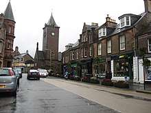
Settlements
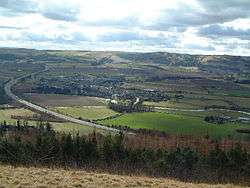


- Aberargie
- Aberdalgie
- Aberfeldy
- Aberfoyle
- Abermyte
- Abernethy
- Abernyte
- Aberuthven
- Achalader
- Achnafauld
- Acharn
- Airntully
- Aldclune
- Almondbank
- Alyth
- Amulree
- Ardeonaig
- Ardler
- Ardtalnaig
- Auchterarder
- Balbeggie
- Ballinluig
- Balquhidder
- Bankfoot
- Blackford
- Blair Atholl
- Blairgowrie
- Braco
- Bridge of Balgie
- Bridge of Earn
- Bridge of Tilt
- Burrelton
- Callander
- Cambuskenneth
- Campmuir
- Caputh
- Carpow
- Clunie
- Collace
- Cottown
- Coupar Angus
- Crianlarich
- Dunkeld and Birnam
- Comrie
- Craigie
- Crieff
- Dalguise
- Deanston
- Doune
- Dowally
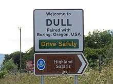
- Dull
- Dunblane
- Dunkeld
- Dunning
- Edradynate
- Errol
- Fearnan
- Findo Gask
- Finegand
- Forgandenny
- Forteviot
- Fortingall
- Fowlis Easter
- Gartmore
- Glencarse
- Grandtully
- Grange
- Greenloaning
- Guildtown
- Harrietfield
- Huntingtower and Ruthvenfield
- Inchture
- Inchyra
- Inveraman
- Invergowrie
- Invermay
- Kenmore
- Kettins
- Killicrankie
- Killin
- Kilspindie
- Kinloch
- Kinlochard
- Kinloch Rannoch
- Kinnaird, Atholl
- Kinnaird, Gowrie
- Kinorssie
- Kirkmichael
- Kirkton
- Lawers
- Leetown
- Lochearnhead
- Logierait
- Longforgan
- Luncarty
- Madderty
- Meigle
- Meikleour
- Methven
- Moneydie
- Monzievaird
- Murthly
- Muthill
- Old Blair
- Perth
- Piperdam
- Pitcairngreen
- Pitkeathly Wells
- Pitlochry
- Pool of Muckhart
- Powmill
- Rait
- Rattray
- Redgorton
- Rhynd
- St Fillans
- St Madoes
- Scone
- Spittal of Glenshee
- Spittalfield
- Stanley
- Strathtay
- Strathyre
- Thornhill
- Tibbermore
- Tullibardine
- Tyndrum
- Waterloo
- Weem
- Wolfhill
- Woodside
Transport
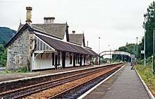
The Highland Main Line railway line connects Perth to Inverness, and in the far west the West Highland Line criss-crosses the Perthshire-Argyllshire boundary. Other lines in the south-east link Perth to the towns of Fife and Stirlingshire.
Parliamentary constituencies
Following the Act of Union, Perthshire returned members to the House of Commons of the Parliament of the United Kingdom from 1708.
1707–1885
- The Royal Burgh of Perth originally formed part of the Perth burghs constituency along with burghs in Fife and Forfarshire. The Representation of the People (Scotland) Act 1832 made Perth a separate burgh constituency.
- The remainder of the county returned a single member as the parliamentary county of Perthshire. The parishes of Tulliallan, Culross, Muckhart, and the Perthshire portions of the parishes of Logie and Fossaway were annexed to constituency of Clackmannanshire and Kinross in 1832.
1885–1918
In 1885 seats in the House of Commons were redistributed: Perthshire received three seats.
- Perth remained a burgh constituency.
- Perthshire Eastern
- Perthshire Western
1918–1975
In 1918 there was a further redistribution. Perthshire was combined with Kinross-shire to form a parliamentary county, divided into two constituencies:
- Perth constituency consisted of the burgh of Perth, the former Eastern constituency and part of the Western constituency. In 1950 it was renamed Perth and East Perthshire. The area included in the constituency was defined in 1948 and 1970 as the burghs of Perth, Abernethy, Alyth, Blairgowrie and Rattray and Coupar Angus; and the Eastern and Perth districts of the county of Perth.[4]
- Kinross and Western Perthshire: the constituency consisted of the entire County of Kinross, the burghs of Aberfeldy, Auchterarder, Callander, Crieff, Doune, Dunblane and Pitlochry; and the Central, Highland and Western districts of the county of Perth.[4]
These boundaries continued in use until 1983, when new constituencies were formed based on the Local Government regions and districts created in 1975.
1975–2005
Perthshire was represented in House of Commons of the United Kingdom from 1975 to 2005.
2005–present
Perthshire has two constituencies and two Members of Parliament.
- Ochil and South Perthshire
- Perth and North Perthshire
Famous places
- Ashintully Castle
- Balvaird Castle
- Birnam Wood and Dunsinane Hill, famous from Shakespeare’s Macbeth
- Blair Castle
- Cateran Trail
- Dirnanean House
- Drummond Castle
- Dunkeld Cathedral
- Edradour Distillery
- Gleneagles Hotel
- The Hermitage
- Kindrogan House
- Scone Palace
- Near Strathtay and Strathmore, where many four-poster stone formations can be found
Notable people
- Archbishop Patrick Adamson
- Duke of Atholl
- James Bannerman
- Edward Braddock
- Sir Archibald Campbell, 1st Baronet
- James Croll
- Alan Cumming
- Sir Charles Douglas
- David Douglas
- Daniel Dow
- Duleep Singh
- Alexander Duff
- Thomas Duncan
- Adam Ferguson
- Duncan Forbes
- Stephen Hendry
- Lady of Lawers
- Alexander Mackenzie
- Dougie MacLean
- John James Rickard Macleod
- Ewan McGregor
- Sir Charles Menzies
- Baron Reid
- J.K. Rowling
- James Small
- Major-General John Small
- William Small
- Rory Stewart
- Robert Stirling
- George Thompson, recipient of the Victoria Cross
- John Sen Inches Thomson
- Dr William Marshall
Schools
- Ardvreck School
- The Community School of Auchterarder
- Blairgowrie High School
- Craigclowan Preparatory School
- Dollar Academy
- Glenalmond College
- Kilgraston School
- Morrison’s Academy
- Perth Academy
- Perth Grammar School
- Perth High School
- Pitlochry High School
- Rattray Primary School
- Strathallan School
- Inch view primary and nursery school
See also
- Earl of Perth
- Glasgow Perthshire Charitable Society
- Highland Perthshire
- Perthshire Rugby Football Club
- Perth and Kinross
- Scottish Highlands
- Stirling
- Trossachs
- List of counties of Scotland 1890–1975
References
- Patton, David (1977). Arms of the County Councils of Scotland. Port Charlotte: Argyll Reproductions Ltd.
- Wilson, John Marius. "The Imperial gazetteer of Scotland; or, Dictionary of Scottish topography". Edinburgh A. Fullarton. Archived from the original on 5 August 2016 – via Internet Archive.
- "walkhighlands Ben Lawers". walkhighlands.co.uk. 2013. Retrieved 20 October 2013.
- The Parliamentary Constituencies (Scotland) Order 1970 (S.I. 1970 No. 1680)
| Wikimedia Commons has media related to Towns and villages in Perth and Kinross. |
| Wikimedia Commons has media related to Perth, Scotland. |